Original Virginia Land Grants
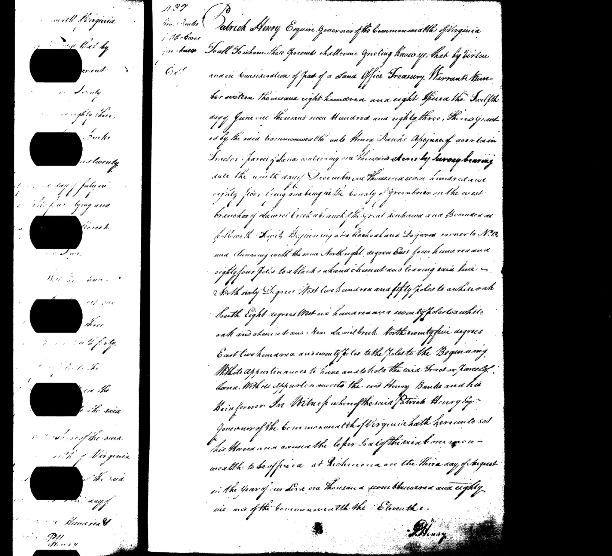
The parcel sits on ground that was Greenbrier County, Virginia until Nicholas County was carved out in 1818 — land first parcelled in the post-Revolution scramble for western Virginia. The oldest patent that names the parcel's own creek is the 1786 Henry Banks "Laurel Creek" grant reproduced on this page; here is where it and its neighbours fall in time.
The patents & surveys, in order
- 1785The survey behind the grant. Henry Banks's 1,000 acres on Laurel Creek are surveyed on December 9, 1785 — the plat the patent would issue upon. The Greenbrier County surveyor of that era was Alexander Welch.
- 1786Henry Banks — "Laurel Creek," 1,000 acres. The oldest dated patent that names the parcel's own creek: "Laurel Creek a branch of the Great Kanhawa" (the Gauley/Kanawha side). Virginia Land Office Grant Book 1, p.437; signed by Gov. Patrick Henry. (The scan on this page.)
- 1787Parker & Warder — "Forks of Gauley," 4,000 acres. The other early dated patent squarely on the parcel's Gauley drainage.
- 1795The county namesake's patents — but on other creeks. Wilson Cary Nicholas (10,785 ac; Grant Book 32, p.536) and Edward Young (2,514 ac; p.318) take grand "Big Laurel Creek" patents — on the Elk and New River "Big Laurels," different creeks from the parcel's (see below).
- UndatedThe survey-only entries. John Hamilton's 500-acre "Peters Creek" survey — the county founder's tract — and the Grose family's "Big Laurel" / "Laurel Creek" surveys were entered and platted but never matured into recorded patents, so no grant book holds them. (Reger's 1921 geology report independently places "Keenan Branch of Peters Creek" in Grant District — tying Hamilton's Peters Creek to the parcel's own Keenan Branch.)
Which "Big Laurel"? — three different creeks
The two 1795 "Big Laurel Creek" patents were pulled and read from the Library of Virginia grant-book images, and they settle the question: neither is the parcel's own Laurel Creek.
- Wilson Cary Nicholas, 10,785 ac — Virginia Land Office Grant Book 32, p.536 (Gov. Robert Brooke, sealed Jan. 1796; the older "Book 3, p.563" citation was a mis-indexed OCR figure). The manuscript places the land "on the heads of the North branches of Greenbrier River and some small Branches of Big Laurel Creek a Branch of Elk River" — the Elk drainage of northern old Greenbrier, not the parcel's ground.
- Edward Young, 2,514 ac — Grant Book 32, p.318 (Gov. Robert Brooke, 1795). Its "Big Laurel Creek, a branch of New River," on the Dogwood Knobs, is a third distinct Big Laurel (it adjoins a 1,076-ac survey made for Henry Banks — a different Banks tract from the 1786 Laurel Creek grant).
So "Big Laurel" named at least three separate streams in old Greenbrier — the Elk branch (Nicholas), the New River branch (Young), and a Meadow-River "Big Laurel" on the south-east side. The patent that names the parcel's own creek remains the 1786 Henry Banks grant — "Laurel Creek a branch of the Great Kanhawa," the Gauley/Kanawha side near Kesslers Cross Lanes. So although Wilson Cary Nicholas's grand patent carries the county namesake's name, it belongs to a different watershed and is not part of this parcel's history — which is why only the Banks grant is reproduced here.
A note on the record
- "Willis Nichols" = Wilson Cary Nicholas. The unfamiliar "Willis Nichols" survey the 1873 deeds recite is almost certainly a garble of Wilson [Cary] Nicholas, the county's namesake, whose 1795 patents blanket this region.
- Where the surveys live. The Virginia Land Office kept the pre-grant survey plats as a series separate from the grants — and, unlike the grant books, they are not digitized. The Banks 1785 Laurel Creek survey and its neighbours survive on Library of Virginia microfilm (Land Office Reels 191–287, filed under Greenbrier County → "Banks, Henry"), borrowable by interlibrary loan, or in login-gated form on FamilySearch. The undated Hamilton and Grose entries, never having matured, have no grant-book plat at all.