The Morning Hays Farm
The full technical record lives in the research edition.
In the hills of Grant District, Nicholas County, West Virginia, several miles southwest of Summersville, in the neighborhood of Poe, some 469 acres of field and woodland fold around two small streams.1 Keenan Branch runs down the middle of the place; Laurel Creek traces its southern edge. Both, along with the rest of this hill country, drain toward the Gauley River. Between them the land carries its oldest names: the branch has borne the name of the family that homesteaded along it since the 1820s.2 The name on the mailbox today is the newest of all. Morning Hays was never written into any old deed. It is a name the present-day family gave the place themselves.
What follows gathers what can be documented about this ground: its surveyed edge, the terrain, the water and the minerals beneath it, and the people who have lived on and around it for more than two centuries. One rule runs through all of it: every distance is measured to the surveyed property line. The farm itself was fields, woods, and a scattering of houses. The things that gave the community its shape (the county's oldest church, its one-room schools, its burying grounds, the little settlement of Poe) ring the land from just outside it. Keeping that line clear is the whole point, so that what belongs to the neighborhood is never quietly handed to the farm.
The farm is a single surveyed parcel, reached by Berkeley Drive off County Route 129. Its outline is a real survey, sixty-nine marked corners set down in West Virginia's public record of property lines, and it does not move: every feature shown on the maps here is placed against that fixed edge.3 Laid out on the ground, it runs about a mile and a half long and a bit under a mile wide, with a small companion tract of three and a half acres along Keenan Branch. The whole of it passed into the family's trust in a 2022 deed that set the record straight on land they already held.
One caution is worth stating plainly, because two things here are easily confused. A coal company once drew a line around roughly 132 acres of this ground for a surface mine, but the state turned the plan down, and the company gave the idea up for good around 2013. The mine was never approved and never dug. The surveyed property line, not that abandoned plan, is what defines the farm.
The most surprising thing about the place is how much of it runs deep. The family owns not just the surface but the shallow coal beneath it and the oil and gas below that, all held outright. In this part of the country the coal, oil, and gas under a farm are usually sold off piece by piece over the years, ending up with strangers who never set foot on the land. Here almost nothing has been split away. Only the deepest coal, the beds that lie below the level streams drain to, was ever sold off on its own, and even that sits under the neighboring tracts, not under this one.4 For Appalachia, where the surface of a place and everything under it are so often owned apart, this land is unusually whole.
Six shallow gas wells sit on the farm, drilled between 1975 and 1979 to depths of roughly 1,200 to 1,400 feet. Two of them still carry the family name on the state's rolls, a reminder that the family owned the gas and leased it out to be drilled. All six have long since been shut in and abandoned. The deep shale gas far below, the kind the modern drilling boom chases, has never been leased and stays with the family trust; this corner of the county lies outside the ground where that deep gas has proved worth the drilling.5
The coal story here is quieter than the region's reputation would lead you to expect. Two worked-out underground mines just nick the farm's northeastern corner, and most of both lie off the property, east on neighboring land. About fifty-four acres bear the scars of old surface mining, the kind done before the mining-cleanup laws of the late 1970s. The large modern strip mine that was once proposed was never built. Before any of that, the land was simply forest, yellow poplar and oak, and its older deeds still name the timber men who once worked it, among them the Flynn Lumber Company and the tract long known by W. W. Keenan's name.
The branch is named for Robert Keenan, who came from Pennsylvania about 1823, bought roughly 150 acres, and married Olive Boone Van Bibber, her names tying the family into the Boone and Van Bibber pioneer lines of the Gauley frontier. By the 1850 census his farm stood shoulder to shoulder with the Koontz, Grose, Brown, and Hamilton households: the everyday neighborhood of this ground.6 One neighbor's boy, Arthur Burke Koontz, born nearby at Kesslers Cross Lanes, grew up to earn a law degree from Yale and become, in 1920, the Democratic nominee for Governor of West Virginia. The "A. B. Koontz" whose name marks one of the farm's old gas wells was, in other words, the boy from down the road.7
The one built place that truly borders the farm is Bethel United Methodist Church, with its Bethel and Brown cemeteries, out on County Route 129 about a fifth of a mile beyond the southwestern corner. A log church was raised here around 1810, making Bethel the oldest church in Nicholas County; its cemetery holds graves cut before the Civil War.8 Just past it, at the same corner, sits the little settlement of Poe, whose post office opened in 1901 and whose name honors the poet Edgar Allan Poe.9 The valley-bottom houses that show up on the old maps, the actual homes of the people who farmed here, cluster in the southwestern flat, and they appear on maps from 1913 down through the 1960s.10
The family that owns the land today came to it from a different world. The Dalportos are an Italian-American family with roots near Lucca, and their West Virginia beginnings lie in the Italian coal-mining towns of the Upper Kanawha Valley, southeast of Charleston. Secondo Dalporto Sr., his wife Norma Nutter Dalporto, and their son John bought the farm together in 1973, from the Duke Coal Company, the land's owner just before them. Their son John Secondo Dalporto (1947–2017), a lawyer for some twenty years in the West Virginia Attorney General's office, was the farm's driving spirit. His own obituary listed him, among much else, as a pond builder, a waterfall architect, an excavator enthusiast, and a maker of maple syrup: the portrait not of a working commercial farm but of a large, beloved retreat given over to ponds and waterfalls and sugaring. The name he gave it, Morning Hays, is his own pun on the morning haze, the dawn fog that pools in these Gauley hollows. It is of a piece with the affection and wit that had him leave behind a "maple syrupery" in his own obituary.11
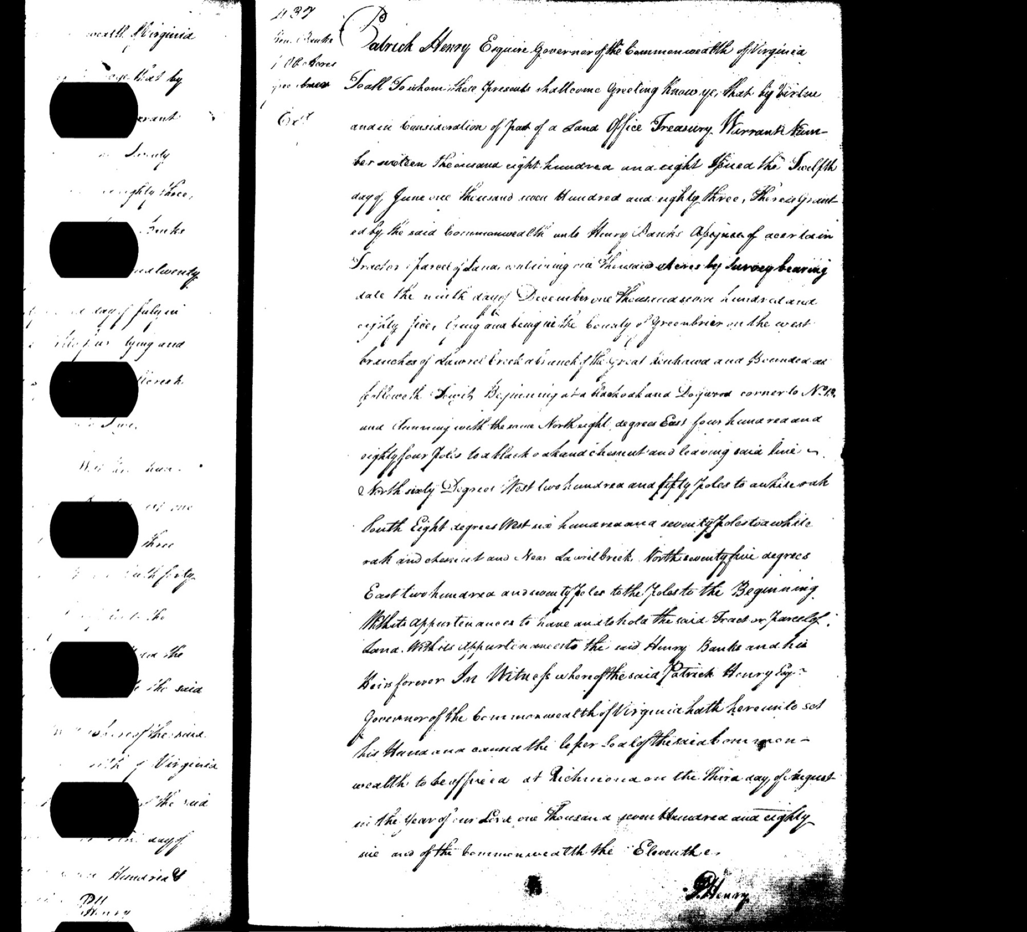
Behind these names the ownership runs back a very long way, through Nicholas County's oldest local deeds of 1873, and past them to the original Virginia land grants of the frontier.12 The oldest dated grant to name the parcel's own creek went to Henry Banks in 1786: a thousand acres on Laurel Creek, its handwritten page signed by Governor Patrick Henry.13 Older claims by John Hamilton, the founder of Nicholas County, and by Wilson Cary Nicholas, the county's namesake, hover at the edges of the record as well.14
The farm is held now by the Jeannean C. Dalporto family trust, the current chapter of a story that reaches from Patrick Henry's signature to a maple syrupery. The pages and maps that follow trace each of its layers in turn: the boundary and the terrain, the water and the minerals, and the two centuries of families who gave this ground on Keenan Branch its names.
Notes & sources
The deed records the farm as 469.224 acres, surveyed along Laurel Creek and Keenan Branch.↩︎
Robert Keenan (born about 1791 in Pennsylvania) settled the branch that bears his name around 1823. The 1850 U.S. Census for Nicholas County lists his farm among the Koontz, Grose, Brown, and Hamilton households.↩︎
The surveyed outline is taken from West Virginia's public record of property lines.↩︎
The deed itself sets out which coal beds the family kept and which were sold off long ago. Among the shallow beds it retained, it names the Douglas, Gilbert, and Eagle seams, and it records that the deep coal sold off separately lies beneath the neighboring tracts.↩︎
The six shallow wells appear in West Virginia's oil-and-gas well registers; they were drilled between 1975 and 1979, and the deeper rights remain with the family trust, unleased.↩︎
Robert Keenan (born about 1791 in Pennsylvania) settled the branch that bears his name around 1823. The 1850 U.S. Census for Nicholas County lists his farm among the Koontz, Grose, Brown, and Hamilton households.↩︎
Arthur Burke ("A. B.") Koontz (1885–1963) was born at Kesslers Cross Lanes, took his law degree at Yale in 1910, and was the 1920 Democratic nominee for Governor of West Virginia.↩︎
Bethel United Methodist Church and its Bethel and Brown cemeteries stand on County Route 129 at Poe. A log church was raised here about 1810, the oldest in Nicholas County; the site carries a West Virginia historical marker.↩︎
The Poe post office opened on December 20, 1901, with Luella H. Burdett as its first postmaster; the community's name honors the poet Edgar Allan Poe. Poe remains a deliverable address today.↩︎
The valley-bottom houses, churches, and schools appear on the U.S. Geological Survey's historical topographic maps of the area, from 1913 through the 1960s.↩︎
From the obituary of John Secondo Dalporto (1947–2017), Barlow Bonsall Funeral Home, Charleston. The Dalporto family's West Virginia roots lie in the Italian coal-mining communities of the Upper Kanawha Valley.↩︎
The chain of title runs back through an 1873 Nicholas County deed among the Keenan and Koontz families, which itself recites three still-older surveys: John Hamilton's grant, the Grose surveys, and a Willis Nichols survey.↩︎
Henry Banks's 1,000-acre "Laurel Creek" patent of 1786 survives as a handwritten page in Virginia's land-grant records, signed by Governor Patrick Henry, and held at the Library of Virginia.↩︎
John Hamilton's 500-acre "Peters Creek" grant, long read as a survey that never matured, in fact recorded as a grant on December 20, 1820 (Virginia Land Office Grant Book 70); Hamilton, remembered as the founder of Nicholas County, had died in 1818, and the grant issued after his death. Wilson Cary Nicholas's 10,785-acre "Big Laurel" grant of 1795 lay on a different creek of that name, over toward the Elk River.↩︎
Who Lived Here
Some pieces of ground are quiet all their lives. This one was not. The creek that runs through the middle of it still carries the name of the family who settled along it in the 1820s. The oldest church in the county stands just past the fence. A Civil War battle was fought two miles off. And the name a visitor meets today, Morning Hays, turns out, against all that age, to be the most recent thing on the place: not a name handed down, but one the present-day family made up. This is the story of the people who lived on the roughly 469 acres now called the Morning Hays, or Dalporto, farm, told from the creek outward, with every distance measured honestly against the property line, so that things "near Poe" are never quietly folded into the farm itself.
The most important habit in a history like this one is also the simplest: measure, don't guess. Almost everything memorable in this pocket of Grant District (the oldest church in the county, the one-room schools, the burying grounds, the little settlement of Poe) sits just outside the fence, not on the ground itself. The tract is a modest one, only about a mile and a half long and a bit under a mile across, so a feature half a mile past the line can feel like part of the farm when it is really a neighbor's.
Held to the property line, the picture comes clear. Truly on the land are three things: the two creeks (Keenan Branch, which runs down the middle, and Laurel Creek, along the south edge) and a scatter of houses in the southwest valley bottom, small black squares on the old survey maps that mark where the working families actually lived. The land also still carries a mailing address, Poe, West Virginia 26683, and the center of that zip code falls essentially on the farm.
Everything else rings it from just beyond. Closest is Bethel church and its burying ground, barely a fifth of a mile off the southwest corner. The hamlet of Poe, its post office and its school, sits at that same corner, a third of a mile out. Beyond them, a ring of one-room schools, small settlements, and family cemeteries stands within a mile or two: Bell School to the north, at the head of Keenan Branch; the Pierson chapel and its graveyard about a mile northeast, on a neighbor's farm; the settlement of Zela and Keenan Cemetery a little over a mile north; Winebrenner School to the northwest; the older settlement of Tipton about a mile and a half west; and Kesslers Cross Lanes, with its own school, roughly a mile and a half to the southeast. Farther still, three to seven miles and more, lie the Civil War battlefields, the town of Summersville, and the lake behind its dam. Held at those distances and named for what they are, each belongs to the story without pretending to belong to the farm.
A rough chronology
- 1786Henry Banks, an absentee investor who never set foot here, is granted 1,000 acres on Laurel Creek.1
- 1791Henry Morris builds the first cabin in what will become Nicholas County, over on Peters Creek.2
- 1795Wilson Cary Nicholas, the county's future namesake, is granted a "Big Laurel Creek" tract, but on a different Big Laurel, in the Elk River country, not the parcel's own creek.3
- ~1800–1814German-descended Grose (or Groves) and Koontz families arrive from Pennsylvania.
- ~1810A log church is raised at Poe: Bethel, the oldest church in Nicholas County.4
- 1818Nicholas County is created on January 30; its first court meets at John Hamilton's home near Kesslers Cross Lanes.
- ~1823–24Robert Keenan settles the branch that will take his name, on 150 acres bought from Joel Hamrick, and marries Olive Boone Van Bibber.
- 1844The earliest dated burial at the bordering Bethel/Brown Cemetery: Amanda Brown.
- 1850–1870Three censuses show the Keenan, Koontz, Grose, Brown, and Hamilton farms as immediate neighbors here.
- August 26, 1861The Battle of Kesslers Cross Lanes, about two miles southeast.
- 1873The oldest surviving local deeds naming the Keenans and Koontzes.
- 1885Arthur Burke Koontz is born at Kesslers Cross Lanes; he will be the 1920 nominee for governor.
- 1885The farmhouse is built; its salvaged date stone names John D. Groves, of the Grose family who settled the creek.
- 1901The Poe post office opens, with Luella H. Burdett as its first postmaster (December 20).
- 1913Bell and Winebrenner schools first appear on the maps; a "100 ACRE FARM. On Keenan Branch… $2000" runs for sale in the Nicholas Chronicle.
- 1918Private Marven R. Rutledge of Poe dies of wounds in the First World War.
- 1933A Depression-era school reform folds Grant District's one-room schools into a single county system.
- 1941James Jacobs, a soft-drink maker, buys the farm and runs a small soda-bottling works in its outbuildings, putting up Flip and Dr. Swett's Root Beer.
- 1945A. B. Koontz Jr. is killed in the Second World War.
- 1965James Jacobs dies at Poe; the farm passes through the Nicholas County Bank's trustee toward the Duke Coal Company.
- 1973John, Norma, and Secondo Dalporto buy the roughly 469 acres from the Duke Coal Company.5
- 1989–1995The Poe post office is suspended and then closed; mail moves to Kesslers Cross Lanes, though the Poe zip code still works.
- 2001 / 2013 / 2017The deaths of Secondo Dalporto Sr., Norma Nutter Dalporto, and John Secondo Dalporto.
- TodayThe land is held by a family trust in Jeannean C. Dalporto's name; John's name for it, Morning Hays, is the newest thing on the ground.
The families who lived here
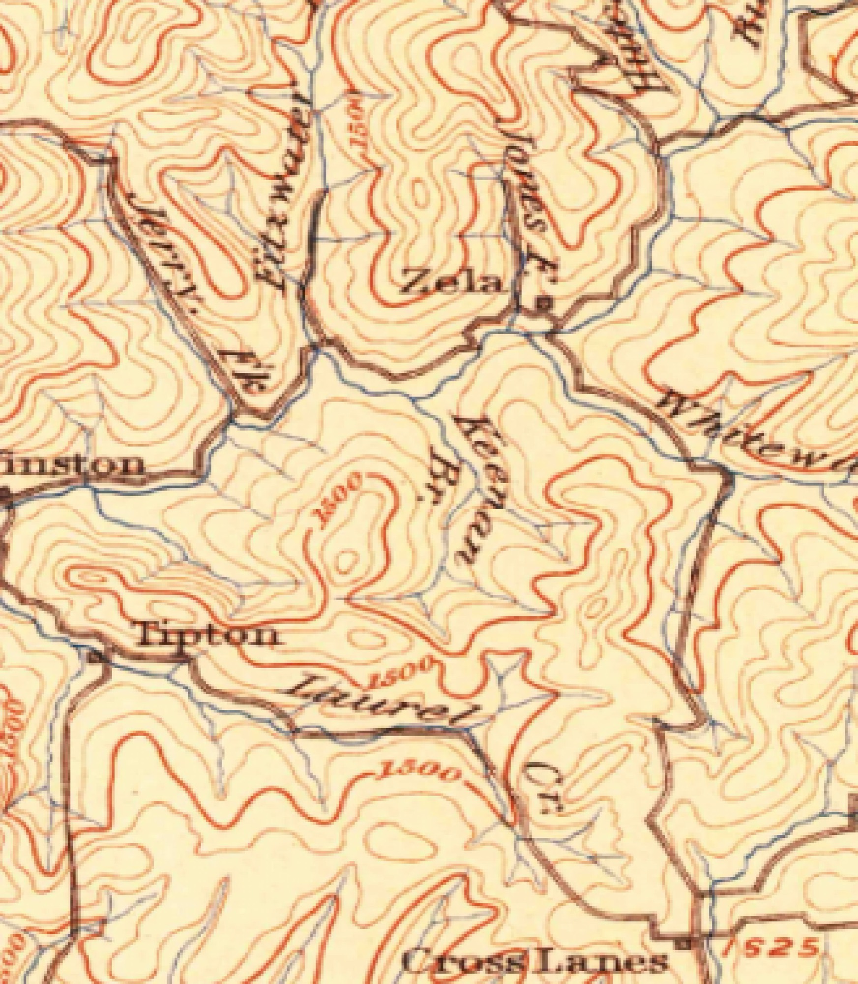
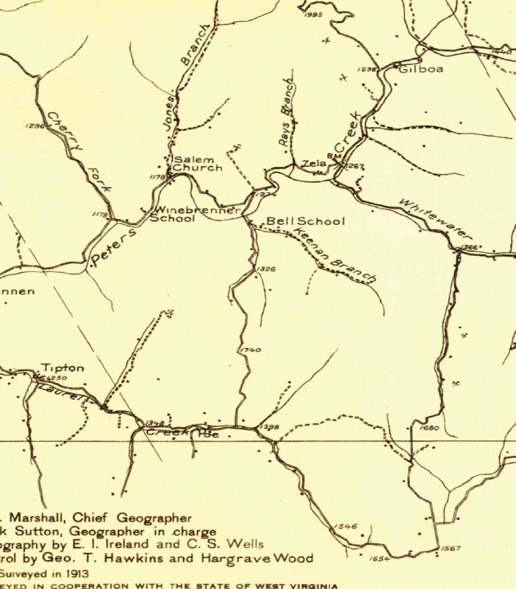
The land itself carries three living marks of its human past. Two are the creeks: Keenan Branch through the middle of the tract and Laurel Creek along the south, the first of them named for the family who homesteaded it in the 1820s. The third mark shows up on the old maps as a scatter of dwellings, small black squares in the southwest valley bottom, present on both the 1913 and the 1967 topographic maps. Those squares are the actual houses of the people who worked this ground.6
The one institution that genuinely borders the farm is Bethel United Methodist Church and its Bethel/Brown Cemetery, on County Route 129 just a fifth of a mile off the southwest corner. Bethel is, by its 2001 state historical marker, the oldest church in Nicholas County. Traveling preachers met in homes until a log church went up here around 1810. The congregation split North and South in 1844, the year the Methodists divided nationally over slavery, nearly two decades before the country did, and afterward services here alternated between the two sides. In 1868 the Reverend Jordan and his members raised a poplar-sided meeting house, the first church painted white in the county; it was remodeled after 1960 and the congregation is active still. Its founding families were the Backus, Walker, Johnson, Linager, Brown, Nutter, Dorsey, Simms, Grose, and Hamrick families.7
The Bethel/Brown Cemetery is the community burying ground at Poe: 221 graves, transcribed by Garnet Martin in 1999. Its earliest dated stone belongs to Amanda Brown, who died in 1844, and birth years reach back to 1818, a graveyard older than the Civil War. Its surnames run heaviest to Gray, Brown, and Burdette (the Poe postmaster family), then Backus and Johnson, and it also holds Keenans, Morrises, and Groses, the farm's own families among them.8 It is the only burying ground actually on the county road at Poe, hard by the intersection. A second, tiny early plot, the Neil Family Cemetery, also lies in the Poe area; its one legible stone is that of Margaret Neil, 1811–1841, the rest worn-blank field stones.9
The families whose names fill those stones begin with the Keenans, who gave the middle creek its name. Robert Keenan, born about 1791 in Pennsylvania, came to Grant District around 1823, bought roughly 150 acres from Joel Hamrick on what became Keenan Branch, and in February 1824 married Olive Boone Van Bibber, her names tying the family into the Boone and Van Bibber pioneer network of the Gauley and Kanawha frontier.10
The Keenans stand on the ground in three straight federal censuses. In 1850 the census-taker found "Robert Keenan, 58, farmer, born Pennsylvania," with $2,100 in real estate, his wife Olive, forty-four, and eleven children; his eldest son, William V. Keenan, twenty-five and already farming, kept the very next house.11 By 1860 the aging patriarch was still there, with sons David, William V., Andrew, James M., and Philip D. close by. In 1870 the Keenans cluster on consecutive dwellings, cheek by jowl with the Koontz, Grose, Brown, and Hamilton families, the physical neighborhood of the farm made visible in the very order of the census pages.12
Their burying ground is Keenan Cemetery, a little over a mile north of the parcel near Drennen and Zela: 249 graves, Keenan the leading surname, with Drennen, Preast, Morris, and Grose kin among them. It pins the settler line with dates: William Van Keenan, born November 1, 1824, died 1901, who married Electra "Lecta" Grose in 1848; Noah, born 1826; David, 1831–1920; Edward McClung, born 1838; and W. W. Keenan, 1849–1916, confirming that the "W. W. Keenan Tract" in the old records names a real later-generation Keenan and not a misreading. Mary Pierson Keenan, 1861–1925, records a marriage joining the farm's family to the neighboring Pierson farm.13
A caution worth keeping: the deep genealogy, a descent from an Irish immigrant Edward Keenan, is probable, not proven. There is another prominent regional Edward Keenan behind an unrelated Keenan community in Monroe County. The Nicholas County settlement facts are solid; the immigrant-generation parentage is not.
The Keenans' nearest neighbors were the Koontz family, Pennsylvania-German farmers at Kesslers Cross Lanes. In 1850 James Koontz, fifty-three, a farmer with $2,000 in real estate, headed the household with his wife, Rebecca Longanecker. Another of the family, John Koontz, 1835–1911, "spent his entire life as a farmer and stock raiser," served one term as county sheriff, and married Alice Groves, another Koontz-and-Grose tie. John was the father of the most famous name in the farm's later paperwork: Arthur Burke ("A. B.") Koontz, 1885–1963, born at Kesslers Cross Lanes, a Yale-trained lawyer in Charleston, and the 1920 Democratic nominee for governor of West Virginia. The "A. B. Koontz" whose name later attached to the farm's old gas wells was, quite literally, a neighbor kid.14
The Grose family, spelled Grose or Groves interchangeably, was the third leg of this intermarried cluster, and a distinguished one. William Grose's son George Richmond Grose became a Methodist bishop and president of DePauw University, and the family owned the Nicholas Chronicle for some fourteen years. The weave is dense: Grose-Keenan and Grose-Koontz marriages recur across the rolls. The Brown family, heavily represented at the bordering Bethel/Brown Cemetery and named among the Laurel Creek pioneers (Alexander Brown, in a 1930 local history), reaches forward into the farm's own ownership, where Ben P. Brown, Trustee, appears as the seller in 1970.15
One name that long resisted the pattern has now been placed. The names "Jacobs" and "Virginia Jacobs," which turn up in the farm's later deeds and gas-well records, are no early-settler family, for no Jacobs household appears in the 1850, 1860, or 1870 counts for Grant District.16 They belong instead to the man who owned the farm through the middle of the twentieth century. James Jacobs, born in Marietta, Ohio, in 1900, bought the two Laurel Creek tracts in 1941 and held them until his death at Poe in 1965; the "Virginia Jacobs" of a 1979 gas well is his widow, Victoria, keeping a mineral interest after him.17
What Jacobs did here is the farm's most unexpected chapter. His own death certificate gives his trade plainly: soft-drink manufacturer. He ran a small soda-bottling works on the place, in the cinder-block building and root cellar behind the farmhouse, putting up two licensed brands of pop, Flip and Dr. Swett's Root Beer. Dr. Swett's was an old Boston root beer that signed up local bottlers across the country from 1939; Flip was a regional brand with a little cartoon mascot that bottle collectors still trade. The machinery is gone, but its bones remain: a pad for the boiler, a stand for the bottling gear, a cut in the floor for the soda, a shelf of test bottles, and a formula sheet with a chart of colors keyed to acidity. When the roof of the building finally failed, its metal Flip advertising signs were flattened and nailed back down as roofing tin.18
Poe kept its soda-making quiet on purpose. Bottle collectors know the county for a second such venture, "Jinks Beverages," put up by a long-serving county official named Hinkle who, their account runs, mixed and bottled his pop in a converted chicken coop on his own Poe farm but labeled every bottle "Summersville," the county seat, on the theory that no one would buy soda made in such a place.19 Whether Jacobs did the very same cannot be proved from a surviving bottle, but the habit was plainly the local one, and it is very likely why a Jacobs Flip bottle, if any survive, would read Summersville and not Poe, and why so small and homemade an industry left almost no mark on the record. The two works were most probably separate, neighboring ventures rather than one, and are kept apart here for want of any deed tying them together.
Jacobs was not the first to hold the place after the settlers, either. Before him the farm came down through the Grose family who had helped settle the creek. A carved stone salvaged from the old house, still legible, reads "1885, John D. Groves," dating the farmhouse and naming a Grose owner; the place passed to his heir Laura Groves, who married Frank Graves, and the Graveses lost it to the Nicholas County Bank in the Depression. The bank's failure sent it through a trustee to Jacobs in 1941 and, after Jacobs died, back through the bank's trustee to the Duke Coal Company in 1970 and on to the Dalportos in 1973. So the long gap between the settler families and the present owners closes, hand to hand: Grose to Graves to the bank to Jacobs to Duke Coal to Dalporto.20
For most of the years the Keenans farmed here, "Poe" was not yet a place on an envelope. The Poe post office opened on December 20, 1901, its first postmaster Luella H. Burdett, and was run across its life by the Burdett, Groves, and, above all, Rutledge families; no one named Poe ever kept it. The community itself was named in honor of Edgar Allan Poe.21 Before 1901, residents fetched their mail from Kesslers Cross Lanes, settled in 1854, or from Summersville, 1820. From 1901 to 1989 the Poe office served the valley directly, and once zip codes arrived in the early 1960s the address read "Poe, WV 26683." When the Dalportos bought in 1973, the Poe office was still open. It was suspended in December 1989 and closed in June 1995, its mail moving to Kesslers Cross Lanes, yet the Poe zip code is deliverable to this day, its center essentially on the farm, so the parcel still carries a Poe, West Virginia address.22 It is a fitting address for such a place: Rural Free Delivery, the very system that first carried mail out to farms like this one, was born in West Virginia, on routes out of Charles Town in October 1896.
Three one-room schools ringed the farm, all run by the Grant District board until a Depression-era reform in 1933 made the county, rather than the local district, the basic unit for running and paying for schools; the district boards were abolished and the little schools folded together, eventually into today's Zela Elementary.23 Bell School stood about three-quarters of a mile north, at the head of Keenan Branch among the Keenans, and was very plausibly named for the Bell family: Samuel Bell, remembered as "grandfather of all the Bells in the county," and Grafton Bell, a Grant District election officer. Winebrenner School lay a little over a mile northwest toward Peters Creek; the family it was named for is unconfirmed in Nicholas County. Poe School sat in the Poe hamlet off the southwest corner. There was never a Laurel Creek School; children on the south side of the tract went to Poe or to Bell.
The families here were tested by war as well. The Battle of Kesslers Cross Lanes was fought about two miles away, and this neighborhood leaned Confederate. Company D (the "Nicholas Blues" of the 22nd Virginia Infantry) and the Gauley Artillery recruited here; local men were captured as Confederates at Lewisburg in 1862 and sent north to Camp Chase. Specific service records for the Keenan, Koontz, and Grose families could not be confirmed from public sources, and the 1883 federal pension roll, a Union roll, lists none of them, though it does record Union wound-pensioners at Kesslers Cross Lanes, a reminder that the district was genuinely divided.24 In the First World War, Private Marven R. Rutledge of Poe died of wounds, a Poe man, and a Poe-postmaster surname.25 In the Second, Lieutenant Arthur Burke Koontz Jr., 1920–1945, of the Kesslers Cross Lanes Koontz family, was killed in service.26
The Dalporto era
The family that owns the farm came to it from a world away, socially as much as geographically, and never lived on it. The Dalportos are a Lucchese Italian-American family, the surname rooted in the Compito and Capannori district of Lucca, in Tuscany, and their world was the Italian coal-mining towns of the upper Kanawha Valley southeast of Charleston: Smithers, Montgomery, London, Longacre, Harewood, Glasgow. That is where they lived; the Nicholas County place was always a retreat reached from away, never a home on the ground. The immigrant matriarch of the West Virginia branch, Caterena Dalporto, 1857–1945, married at Longacre and lies with some thirteen of her kin at Montgomery Memorial Park.27
The record for the generation just before Secondo Sr. is unusually full. Emilio Dalporto, an Italian immigrant who took out his citizenship papers in Fayette County in 1929, a merchant by then, died at Smithers in 1945, aged fifty-five; his 1942 will divided his estate among his wife, Leitza, and their children Primo, Secondo, Pia, and Virginia.28 That son Secondo is, in all likelihood, the Secondo Dalporto Sr. who would buy the Nicholas County farm a generation later, the thread that ties the Fayette coal country to the ground on Keenan Branch.
By mid-century the family had moved from the mines into business. Secondo Dalporto Sr., 1917–2001, was, by his own community's account, "one of the founding fathers" of Kanawha Valley Memorial Gardens at Glasgow; his gravestone reads "WE LOVE YOU MR. 'D'." He married Norma Lucille Nutter, 1921–2013, of an old Anglo central-West-Virginia family.29 The 1973 purchase by "John, Norma, and Secondo Dalporto," then, was father, mother, and son buying the farm together, out of their base in the Kanawha coal towns rather than as anyone's move onto the land. (One resonant note, unproven: Bethel Church, which borders the farm, counts Nutter among its founding families, and a Reverend N. L. Nutter preached in this valley in 1912, but no source ties either to Norma's line.)
Their son, John Secondo Dalporto, 1947–2017, was the farm's driving spirit. He lived in Charleston and worked roughly twenty years as a lawyer in the West Virginia Attorney General's office, and his estate was settled in Kanawha County: home was Charleston, not Poe. His obituary is the key to what the land was to them. Among many roles, it names him "pond builder, waterfall architect, excavator enthusiast and syruperist."30 Every piece of that describes a large, remote, beloved retreat (ponds, waterfalls, maple syrup, hobby farming) rather than a residence or a working commercial farm. John's heirs, Casey, Gabe, Hannah, and Nathan, survive him, and the land now passes through a family trust in Jeannean C. Dalporto's name.
Of everything on this land, "Morning Hays" is the youngest, and the most personal. The research is clean on the essential point: it is not an inherited historic place-name but the family's own coinage. The phrase turns up essentially nowhere on the open web except the family's own site, which is the fingerprint of a modern name rather than an old one. No Hays or Hayes appears in the deeds, in a nearby cemetery, or as an official place-name on the government maps of this ground. (The famous West Virginia "Hays" family belongs to Gilmer County, about fifty miles north, a confusion to avoid.) The decisive clue is in John Dalporto's own 2017 obituary, which bequeaths, tongue in cheek, "the morning hays maple syrupery (still kidding)," tying the name straight to John and his maple-syruping.31 The meaning is a pun: John coined Morning Hays as a play on morning haze, the dawn fog that pools in these Gauley hollows, of a piece with the "maple syrupery (still kidding)" he left in his obituary. It is an owner-coined name in the fullest sense, not only his to give, but his joke to make.
The wider country
None of the following is "on the farm," but the land sits in an unusually event-rich pocket, and the events are worth placing honestly. The Battle of Kesslers Cross Lanes, on August 26, 1861, about two miles southeast, was the nearest big history to the ground: Confederate General John B. Floyd surprised the 7th Ohio at breakfast, the "Battle of Knives and Forks," and routed them in a fight of thirty to forty-five minutes.32 The founding of Nicholas County in 1818 happened in this very neighborhood, its first court meeting at John Hamilton's home near Kesslers Cross Lanes; Hamilton gave the land for the county seat at Summersville.33 The Battle of Carnifex Ferry, on September 10, 1861, about three to four miles off, is now a state park, and among its Union soldiers were the future presidents Rutherford B. Hayes and William McKinley. Nancy Hart's raid on Summersville in 1862 played out about seven miles away, when the Confederate spy shot her guard, escaped, and came back to burn much of the town.
Summersville Dam, built in the 1960s some seven-plus miles off, backed up the Gauley that Laurel Creek and Keenan Branch feed, and gave rise to the whitewater "Gauley Season." And about two miles away stands a near-twin listed on the National Register of Historic Places: the Captain John Halstead Farm, around 1876, described in its listing as "an example of the local type of residence and subsistence farm," almost exactly what this land once was.34 The larger arc, subsistence farming to timber to coal and gas, is the county's story in miniature, and the Dalportos' 1973 purchase from the Duke Coal Company sits squarely in its coal-and-gas chapter.
The paper trail on this ground runs deep. The earliest map of it, from 1889, already names Keenan Br. and Laurel Cr., with Tipton as the nearest settlement then. "Poe," Bell School, and Winebrenner School first appear by 1913; Bethel Church and the cemeteries are labeled by 1967.35 The earliest aerial photograph of it was taken by the government in 1938–39, and the best early mapping of the county is the state's 1921 geological report on Nicholas County.36 A professional archaeological survey of this exact ground was even carried out around 2010–11, in the course of a state historic-preservation review.37
The old newspapers catch the farm at work. In February 1911 the Nicholas Chronicle reported that "W. W. and H. E. Backus will move their saw mill from the Keenan branch."38 In October 1913 the Summersville real-estate agency Alderson & Peck ran a recurring notice in its "Real Estate Bargains" column: "100 ACRE FARM. On Keenan Branch. Good house and barn. One half in timber. Fine coal. Price $2000." Whether that hundred acres was a piece of today's tract or a neighbor's farm on the same branch can't be told from the ad alone.39 A June 1911 notice to fence the Kesslers Cross Lanes graveyard was signed "H. P. Rippetoe, Poe, W. Va."40 And that same summer the paper carried a note on "A. B. Koontz on the High School," on a page listing the Grant District officers "L. W. Koontz and Grafton Bell."41 The Dalporto era, after 1973, falls past the years that have been digitized (a search for "Dalporto" turns up no West Virginia hits) and survives, if anywhere, only on library microfilm.
Some things here are firm. Keenan Branch and Keenan Cemetery are named for the Keenans; Robert Keenan's substantial 1850 farm and the Keenan-Koontz-Grose-Brown-Hamilton neighbor cluster are documented in the census; A. B. Koontz's local birth and 1920 candidacy are on record; Bethel is the county's oldest church, bordering the farm, with its pre-1844 cemetery; the Poe post office roster and dates are established; the Dalporto family's Lucchese origin, their upper-Kanawha-Valley home, and John's stewardship of the place as a retreat are well attested; and the battles, the dam, and the Halstead Farm all sit at the distances given. Other things are only probable: Robert Keenan's exact 1823 arrival story (the census anchors the family firmly even where the arrival tale rests on secondary genealogies), the derivation of Poe from Edgar Allan Poe, and the judgment that Jacobs is a later ownership layer.
The value of measuring rather than guessing shows in the corrections this research made along the way. Keenan Cemetery is a little over a mile north: nearby, not "adjacent," as an intermediate draft had it. The bordering burying ground is Bethel/Brown Cemetery, a fifth of a mile off, not "Poe Cemetery"; a same-named "Poe Cemetery" turns out to lie at Bluewell, in Mercer County, some sixty-six miles south, a trap caught before it entered this history.42 Pierson Chapel and its cemetery, about a mile northeast, are on the adjoining John A. Pierson farm, not on this parcel, a neighbor's story labeled as a neighbor's. And a deed once read as "1909" for the Pierson church is really from the 1990s, the earlier date a scanning error. Several other look-alikes were ruled out entirely: a Keenan community in Monroe County, the Gilmer County Hays family, a second Bell School seven miles south, a Winebrenners Crossroad in Berkeley County, and a Randolph County "Charles W. Pritt."
This account was built from public records: the federal census, the volunteer-run grave database Find A Grave, postal-service records, the Library of Congress's digitized old newspapers, the government's historical topographic maps, and state historical markers, with every location checked for its true distance to the surveyed property line before it was allowed into the story.
Notes & sources
Virginia land-office grant to Henry Banks, 1,000 acres on Laurel Creek, 1786 (Library of Virginia land grants).↩︎
The West Virginia Encyclopedia (e-wv.org), "Nicholas County."↩︎
Virginia land-office grant to Wilson Cary Nicholas for "Big Laurel Creek" (the one in the Elk River drainage, not this parcel's creek), 1795 (Library of Virginia land grants).↩︎
West Virginia state historical marker for Bethel United Methodist Church (2001); the Historical Marker Database; and a WVU Libraries historical photograph of the church.↩︎
The 1973 deed conveying the farm from the Duke Coal Company to John, Norma, and Secondo Dalporto, recorded at the Nicholas County courthouse.↩︎
The U.S. Geological Survey's historical topographic maps (the 1913 Summersville map and the 1967 Gilboa map) and the earliest sheet of this ground, from 1889.↩︎
West Virginia state historical marker for Bethel United Methodist Church (2001); the Historical Marker Database; and a WVU Libraries historical photograph of the church.↩︎
The Bethel/Brown Cemetery at Poe (221 memorials), transcribed by Garnet Martin in 1999 and recorded on Find A Grave.↩︎
Nicholas County cemetery records compiled by the volunteer WVGenWeb Project (Neil Family Cemetery).↩︎
Nicholas County marriage records via the WVGenWeb Project (Robert Keenan and Olive Boone Van Bibber, 1824).↩︎
1850 U.S. Census, Nicholas County (then Virginia), the household of Robert Keenan.↩︎
Nicholas County census transcriptions, WVGenWeb Project.↩︎
Keenan Cemetery, near Drennen and Zela (249 memorials), on Find A Grave and the WVGenWeb Project.↩︎
Biographical sketch of Arthur Burke Koontz in the USGenWeb Archives for Nicholas County, with Find A Grave and Prabook.↩︎
WVGenWeb Project and West Virginia Archives & History.↩︎
The 1850, 1860, and 1870 U.S. Censuses for Grant District, Nicholas County (transcriptions).↩︎
James Jacobs bought the farm in 1941 from the trustee of the failed Nicholas County Bank and held it until his death at Poe on July 2, 1965 (Nicholas County deed index; West Virginia death records, which name his wife as Victoria).↩︎
James Jacobs's West Virginia death certificate (1965) records his usual occupation as soft-drink manufacturer. The remains of the bottling works survive in the farm's outbuildings: a boiler pad, a mount for the bottling machinery, a cut in the floor, test bottles, a formula sheet keyed to color and acidity, and flattened metal "Flip" signs. Dr. Swett's Root Beer, of Boston, franchised local bottlers from 1939.↩︎
The "Jinks Beverages" bottle, and the account of its maker, a Nicholas County official surnamed Hinkle who bottled in a chicken coop at Poe and labeled the bottles "Summersville," appear in the Federation of Historical Bottle Collectors' magazine, Antique Bottle & Glass Collector (2022).↩︎
The mid-century chain of title, from the Nicholas County deed index: the Grose (or Groves) family; John D. Groves, whose 1885 date stone marks the farmhouse; his heir Laura Groves, wife of Frank Graves; the couple's loss of the land to the Nicholas County Bank by a 1932 trust deed; the bank trustee's conveyance to James Jacobs in 1941; and, after Jacobs's death, the trustee's sale to the Duke Coal Company in 1970 and its 1973 sale to the Dalportos.↩︎
Hamill Kenny, West Virginia Place Names (The Place Name Press, 1945).↩︎
U.S. Postal Service postmaster records and a postal bulletin; zip-code data via zippopotam.us.↩︎
The federal geographic-names database (via GeoNames); and The West Virginia Encyclopedia, "County Unit Plan."↩︎
West Virginia in the Civil War (wvcivilwar.com); Genealogy Trails; and the 1883 federal pension roll.↩︎
Soldiers of the Great War (Soldiers Record Publishing Association, 1920), West Virginia section.↩︎
Find A Grave memorial for Arthur Burke Koontz Jr. (1920–1945).↩︎
Find A Grave memorials for the Dalporto family at Montgomery Memorial Park, Montgomery, W. Va.↩︎
Primary records for Emilio Dalporto via FamilySearch: his Fayette County naturalization papers, filed 1929; his 1942 Fayette County will, naming his wife Leitza and children Primo, Secondo, Pia, and Virginia; and a March 1945 death notice in the Charleston Daily Mail (Emilio Dalporto, 55, of Smithers). Identifying his son Secondo with Secondo Dalporto Sr. (1917–2001) is highly probable but not independently confirmed here.↩︎
Find A Grave memorials for Secondo Dalporto Sr. (1917–2001) and Norma Lucille Nutter Dalporto (1921–2013).↩︎
Obituary of John Secondo Dalporto (1947–2017), Barlow Bonsall Funeral Home, Charleston, W. Va.↩︎
Obituary of John Secondo Dalporto (1947–2017), Barlow Bonsall Funeral Home, Charleston, W. Va.↩︎
American History Central and Wikipedia, "Battle of Kessler's Cross Lanes" (Aug. 26, 1861).↩︎
The West Virginia Encyclopedia (e-wv.org), "Nicholas County."↩︎
National Register of Historic Places nomination for the Capt. John Halstead Farm (c. 1876), Nicholas County.↩︎
The U.S. Geological Survey's historical topographic maps (the 1913 Summersville map and the 1967 Gilboa map) and the earliest sheet of this ground, from 1889.↩︎
David B. Reger, Nicholas County (West Virginia Geological Survey, 1921), digitized on archive.org.↩︎
The West Virginia State Historic Preservation Office's review of historic and cultural sites on this ground (2010–11).↩︎
Nicholas Chronicle, Feb. 16, 1911 (Chronicling America, Library of Congress).↩︎
Nicholas Chronicle, October 1913, the "Real Estate Bargains" column of Alderson & Peck, a Summersville real-estate and insurance agency. The ad lists only the broker and the $2,000 price, not the land-owner; the Keenan Branch tract was one of several in the column. Via Chronicling America (Library of Congress).↩︎
Nicholas Chronicle, June 8, 1911 (Chronicling America).↩︎
Nicholas Chronicle, June 29, 1911 (Chronicling America).↩︎
A same-named "Poe Cemetery" listed on Find A Grave lies at Bluewell, in Mercer County, roughly 66 miles south, and nothing to do with this farm.↩︎
Location & Boundary
The Dalporto farm sits in the folded hills of Nicholas County, West Virginia, along two small streams named Keenan Branch and Laurel Creek. You reach it by Berkeley Drive, a lane that turns off County Route 129 and climbs up into the farm. The little community of Poe lies about a mile to the southwest, and Summersville is several miles off to the northeast. The land rises and falls a good deal from one end of the farm to the other, from around 1,200 feet down in the creek bottoms to about 1,965 feet at the highest ground, just shy of 2,000.1 And every stream that crosses the place is running the same errand: the waters of Keenan Branch and Laurel Creek gather and go down to Peters Creek, into the Gauley River, and on by way of the Kanawha to the Ohio, a long road to the sea that begins right here in these hills.
What people mean when they say "the farm" is really one surveyed piece of ground: a single tract of some 469 acres, owned outright by the Dalporto family.2 The deed sets it down in the plainest language: the surface of the land along Laurel Creek and Keenan Branch. A small companion piece of about three and a half acres, down along Keenan Branch, comes attached to it.3 All told the tract runs roughly a mile and a half one way and not quite a mile the other. There is one wrinkle worth knowing. When the state's mapping office traces the outline on its own computer maps and measures what lies inside, the number comes out a little smaller, around 431 acres. But the figure written into the deed, the one that counts as the official acreage on record, is the larger one: some 469 acres.4
Two boundaries, one piece of land
The paper record of this land holds two different outlines, laid one over the other, and they are easy to mix up. The first is the one that matters for a map of the farm: the surveyed property line of the land the family owns, its true outer edge, traced corner to corner and kept on file with the state so that anyone can call it up. An older mining map once drew the very same tract more loosely and rounded it off to "about 486 acres," a rough guess at the surveyed figure and nothing more.
The second outline belongs to something that was drawn up but never dug: a coal operation called the Keenan Branch Surface Mine, put forward by a company called Keenan Minerals. Had it gone ahead, it would have taken in part of the Dalporto land together with several neighboring tracts. Its shape has nothing in common with the property line, and unlike that line it never hardened into anything real: it lives only as ink on a drawing. The mining maps carry no surveyed corners; the outline was sketched by hand, meant to be paced off and staked in the field with numbered posts once digging began. The planned footprint even changed as the drawings were redone: an early version reached across about 211 acres, a later one only about 132. It shows up on no official state map, because the application was never approved or backed by a bond. The mine was never built.
On the mine company's own paperwork the Dalporto land is written down simply as "Tract 1," with the family named as the owner of the surface. Scattered through those same papers is a whole constellation of marked points, thirty-nine in all: holes drilled to test the coal, spots along the streams set aside to keep watch on the water, the mine's own anchor point, and the places where it would have let its runoff out. They are useful for getting one's bearings, but not a single one of them is a corner of the farm; every last point belongs to the mine, not the land. The plan would also have reopened an old mining bench (a flat shelf of ground, stripped bare, that a company called Greenbank Coal had worked years before), the very re-mining the whole application was built around. None of it ever came to pass. And so, for the real boundary of the farm, the answer is the one thing that is fully surveyed, settled, and open to anyone who cares to look: that single tract of some 469 acres.
Notes & sources
On the U.S. Geological Survey's topographic maps (the government's detailed survey sheets, each covering a small rectangle of country and named for a nearby landmark), the farm falls on the sheet called Gilboa.↩︎
The land is held in the family's trust, in the name of Jeannean C. Dalporto as trustee; the earlier owner of record was John S. Dalporto.↩︎
The companion piece measures 3.520 acres, along Keenan Branch, and is carried on its own line in the Nicholas County deed books.↩︎
The deed puts the figure precisely at 469.224 acres and describes the property as the surface of the land along Laurel Creek and Keenan Branch, as recorded in the Nicholas County deed books. Measured instead on the state's computer maps, the enclosed area comes to roughly 431 acres; the deeded figure is the one of record.↩︎
Land Grants
Long before it was a Nicholas County farm, this ground lay in Greenbrier County, Virginia, and it stayed Greenbrier land until 1818, when Nicholas County was carved out of it. Its first title on paper dates to the unsettled years just after the Revolution, when western Virginia was handed out in a scramble of claims made mostly by men who had never laid eyes on the land. Out of that scramble, the oldest dated grant to name the farm's own creek is a 1786 patent (an old word for a land grant) to a speculator named Henry Banks, the document copied onto this page. What follows explains first how such a title was made, then places this grant, and its neighbors, in order.
How a frontier title was made
Titles like the Banks grant came out of the land system Virginia set up after the Revolution. Under the state's land law of 1779, a man who wanted land did not ask for a particular piece of it. He bought a warrant from the state treasury, paying a fixed price for every hundred acres, and that warrant let him claim that many acres of unclaimed public land ("waste and unappropriated," as the law put it) wherever he could find ground no one else had taken. He handed the warrant to the county surveyor, who went out and marked off an actual tract on the ground, then sent the drawing back to the land office in Richmond. Only after that, and after a set waiting period for rival claims to surface, did the grant itself go out under the governor's signature and make the title real. Nothing in that chain required the new owner to lay eyes on the land, live on it, or cut down a single tree.
That gap turned western Virginia into a speculator's market. Investors bought warrants by the thousands of acres and claimed far-off frontier land sight unseen, betting they could sell it later to the settlers who were sure to come. Henry Banks was one of these absentee dealers, not a Laurel Creek homesteader. The records on this page alone catch him holding more than one western tract: the thousand acres on Laurel Creek that give the farm's creek its name, and a separate survey of 1,076 acres elsewhere, laid out next to Edward Young's land on the New River.
The survey at the heart of every grant was written as a walk around the edge of the land. Instead of a tidy grid, it followed the boundary from one corner to the next: a corner tree with a mark cut into its bark (a chestnut, a white oak, or a beech), a driven stake, a piled heap of stones, or a crossing of a creek, with the surveyor and the men carrying his measuring chain pacing off each distance and cutting marks into "witness trees" (trees left standing to record the line) along the way, so that every corner could be found again years later. It was a method Virginia had carried west from its older, long-settled counties near the coast, and it tied each early boundary to landmarks that would not last. Trees fell and streams shifted their beds, and that is one reason the overlapping "Big Laurel" claims, and the deeds that lean on them, are as tangled as they are.
The grants and surveys, in order
- 1785the survey behind the grant. Banks's thousand acres on Laurel Creek were walked and measured on December 9, 1785. That survey, the marked-off tract the patent would later rest on, was drawn by the county surveyor of the day and still survives in the old survey records.1
- 1786Henry Banks, Laurel Creek, 1,000 acres. The oldest dated grant to name the farm's own water: "Laurel Creek a branch of the Great Kanhawa," over on the Gauley and Kanawha side. Governor Patrick Henry signed it.2
- 1787Parker and Warder, Forks of Gauley, 4,000 acres. The other early grant that falls squarely on the farm's own ground, where the water runs toward the Gauley.
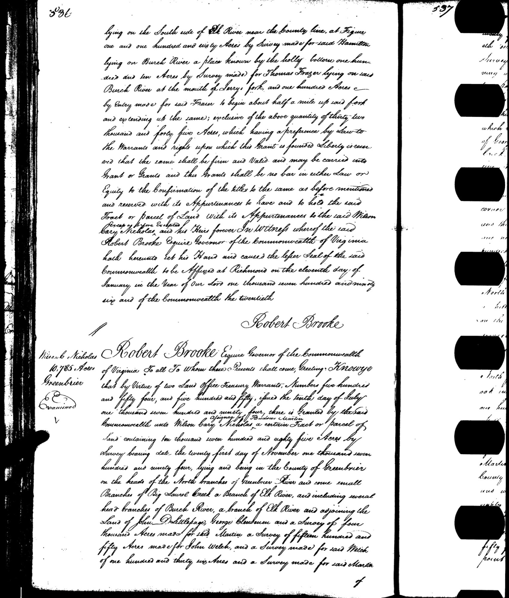
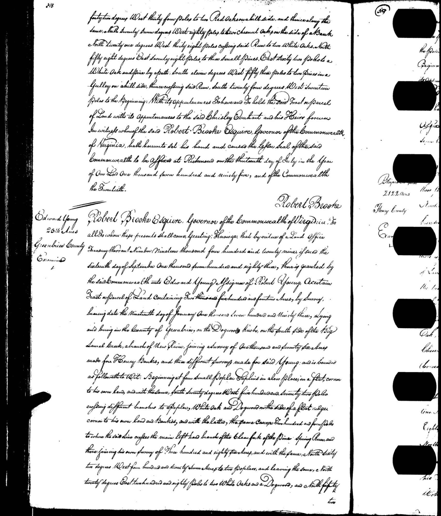
- 1795the county's namesake, but on other creeks. Wilson Cary Nicholas took an enormous patent of 10,785 acres, and Edward Young one of 2,514, both named for a "Big Laurel Creek." But their Big Laurels were other streams entirely, off toward the Elk and the New River, and not the farm's own Laurel Creek.34
- 1820John Hamilton's Peters Creek grant. John Hamilton was one of the county's founders, and his own tract was long read as a survey that never grew into a grant. It did in fact become a recorded grant, on December 20, 1820: "500 acres on the waters of Peters Creek … near Piersons branch."5 A 1921 state geological report independently places a "Keenan Branch of Peters Creek" in Grant District, which ties Hamilton's Peters Creek to the farm's own Keenan Branch.6 The Grose family's "Big Laurel" and "Laurel Creek" claims, by contrast, show up only as surveys; no finished grant for them has ever been found.
Which "Big Laurel"? Three different creeks
Both of the 1795 grants were read straight from photographs of the old Virginia grant books, and set side by side they settle a question the old deeds leave muddy: neither one is describing the farm's own Laurel Creek.
Wilson Cary Nicholas's 10,785-acre grant sets its land "on the heads of the North branches of Greenbrier River and some small Branches of Big Laurel Creek a Branch of Elk River."7 That is the Elk country of the old northern Greenbrier, not the farm's ground. Edward Young's 2,514-acre grant names a different stream again, a "Big Laurel Creek, a branch of New River" up on the Dogwood Knobs;8 his survey lay next to a separate 1,076-acre tract marked off for Henry Banks, which is not the same as Banks's 1786 Laurel Creek grant.
So "Big Laurel" was the name of at least three separate streams scattered across the old Greenbrier country: the Elk branch of Nicholas's grant, the New River branch of Young's, and yet another Big Laurel off to the southeast toward the Meadow River. The grant that names the farm's own creek is still the 1786 Banks patent: "Laurel Creek a branch of the Great Kanhawa," on the Gauley and Kanawha side, near Kesslers Cross Lanes. The grandest name on the whole list belongs somewhere else: Wilson Cary Nicholas's patent carries the county's namesake, and yet it sits in a different watershed and makes up no part of this farm's title. That is why only the Banks grant is copied onto this page.
The confusion of names outlived the grants themselves. The deeds written in 1873 mention an unfamiliar "Willis Nichols" survey, almost certainly a garbled rendering of Wilson Cary Nicholas, the county's namesake, whose 1795 patents blanket the whole region.
The survey drawings that came before the grants sit in a record apart from the grants themselves. Virginia's land office kept its surveys in one series and its finished grants in another, and unlike the grants, the surveys have never been photographed and put online. The 1785 Banks survey of Laurel Creek and its neighbors survive only on old microfilm at the Library of Virginia, filed under Greenbrier County.9 The Grose claims, never having grown into recorded grants, left no drawing in the grant books at all; the Hamilton tract, once read the same way, turns out to have been recorded as a grant in 1820.10
Notes & sources
The survey drawings made before the grants are held in the Virginia land office's separate survey series, surviving on microfilm at the Library of Virginia, filed under Greenbrier County (under "Banks, Henry"). Unlike the grants, they have never been digitized.↩︎
The original patent survives in the Virginia land-office grant books at the Library of Virginia in Richmond; it was signed by Governor Patrick Henry in 1786.↩︎
Wilson Cary Nicholas's patent is preserved in the same Library of Virginia grant books and was sealed under Governor Robert Brooke in January 1796.↩︎
Edward Young's patent is preserved in the same Library of Virginia grant books, issued under Governor Robert Brooke in 1795.↩︎
John Hamilton's grant, "500 acres on the waters of Peters Creek … near Piersons branch," dated December 20, 1820, is recorded among the Library of Virginia's land-office grants and located through the Library's catalog.↩︎
The 1921 report of the West Virginia Geological Survey for Nicholas County, prepared by the geologist David B. Reger under state geologist I. C. White, which places "Keenan Branch of Peters Creek" in Grant District.↩︎
Wilson Cary Nicholas's patent is preserved in the same Library of Virginia grant books and was sealed under Governor Robert Brooke in January 1796.↩︎
Edward Young's patent is preserved in the same Library of Virginia grant books, issued under Governor Robert Brooke in 1795.↩︎
The survey drawings made before the grants are held in the Virginia land office's separate survey series, surviving on microfilm at the Library of Virginia, filed under Greenbrier County (under "Banks, Henry"). Unlike the grants, they have never been digitized.↩︎
John Hamilton's grant, "500 acres on the waters of Peters Creek … near Piersons branch," dated December 20, 1820, is recorded among the Library of Virginia's land-office grants and located through the Library's catalog.↩︎
Deed Chain
Every acre of this farm can be traced backward, owner by owner, through a run of papers filed with the Nicholas County Clerk: deeds, a deed drawn up to correct an earlier one, an agreement to pool the ground for drilling, the settling of an estate. Each is a real document resting in the county land books. Lawyers call the whole succession a chain of title: the line of recorded sales and gifts by which land passes from one hand to the next. When every link joins cleanly to the one before it, with no gap, no forgotten heir, no rival claim, the title is sound, and the land can be bought and sold with confidence. That is why a title examiner, or the attorney for anyone thinking of buying, is paid to walk the chain link by link, exactly as this one can be walked. Read newest to oldest, it runs from the family trust that holds the land today all the way down to a deed from 1873, filed among the names of the county's founding families; and the old surveys those deeds quote reach back further still, to the first land grants issued when this was still Virginia. None of it is secret. Every date, every name, every description can be pulled up, for free, in the county's online land index.1
The property on record is two pieces of ground, both in the Grant District, and both known by the water that crosses them: Laurel Creek and Keenan Branch.
A word about the name "Keenan." Three different things wear it, and they are easy to mix up. Keenan Branch is a stream, a real named creek the farm lies along, which is why the old deeds place the land on Laurel and Keenan. The branch carries the name of an early Nicholas County Keenan family, a name woven all through the county's beginnings. It still turns up close to home: on a gas well on the property, on an old tract that once went by the family's initials, and on the 1873 deed at the bottom of this chain. The stream itself was already lettered Keenan Br. on a U.S. Geological Survey map drawn in 1889, roughly a hundred and twenty years before any coal company by that name existed. Keenan Minerals is that company: a modern outfit, no relation to the family, that leased the deep coal here and once applied to strip-mine the surface, a mine that was never dug. It is not the Dalporto family, and it owns none of the surface; it simply borrowed the creek's name for its permit. The family owns the surface, the shallow coal near the top of the ground, and the oil and gas. Only the deep coal, far below, has been split off and sold away.
Both pieces are held today by Jeannean Dalporto, as trustee of the family's living trust, formally the Jeannean C. Dalporto Inter Vivos Trust, a trust she set up during her lifetime to hold the land. The larger piece is the working farm itself, some 469 acres off Route 129, still carried on the county's books as an active farm.2 The smaller is a slip of about three and a half acres down along Keenan Branch, listed as residential.
The chain, link by link
Newest first, each link a document recorded in the county land books.
- 2022A deed to mend the record. Jeannean Dalporto deeds the farm ("486 acres, Grant District") into the family trust, with two companion deeds recorded alongside it. This one moves nothing. A corrective deed simply re-files an earlier one to fix a mistake in it (a wrong acreage, a garbled description, a name left out) and counts, in law, as of the day of the original. It trails a year behind the 2021 transfer into the trust, tidying that record rather than shifting the land again.
- 2021Into the family trust. The surface, roughly 468 acres, the little three-and-a-half-acre tract, and "486 acres and minerals" pass into the newly made trust, whose founding agreement is filed with them.
- 2018Settling an estate. John S. Dalporto had died the year before; now his heirs deed their shares to Jeannean, one of the papers passing along, for instance, a half interest in the coal, oil, gas, and minerals across Laurel Creek and Keenan Branch.3
- 2004The oil and gas gathered together. Norma Lucille Nutter Dalporto deeds John S. Dalporto her two-thirds share of the oil and gas, across the 486 acres and a separate 97-acre tract, drawing the mineral rights toward a single pair of hands.
- 1992The shallow coal comes home. The Terry Eagle Coal Company gives up whatever claim it holds to the shallow coal seams (the ones lying above the level where the streams drain) and hands them back to John S. Dalporto, who owns the surface. The deep coal stays split off.
- 1978The ground pooled for gas. The Duke Coal Company files a paper combining the tract into a single unit for drilling, its timing matching the string of shallow gas wells put down on the farm between 1975 and 1979.
- 1973The Dalportos buy the farm. The Duke Coal Company deeds the tract to John, Norma, and Secondo Dalporto, about 565 acres, "part surface and part mineral." This is the family's first purchase of the land.
- 1970Duke Coal assembles the tract. Ben P. Brown, as trustee, deeds the same 565-acre tract, part surface and part mineral, to the Duke Coal Company, which puts together the ground the Dalportos will buy three years on.
- 1873The oldest deed here. The Keenan and Koontz families appear in the deepest link the free county index reaches. The surveys it quotes run back further, to John Hamilton's grant and the Grose surveys of the first settlers.
Why the acreage keeps changing
Follow the chain and the same farm keeps turning up under different acreages. It looks like sloppiness. It isn't. Each figure measures the place from a different angle.
The largest, about 565 acres, is the larger original tract as it was assembled and sold between 1970 and 1973. Roughly 468 acres is the reach of the shallow coal, the seams lying above where the streams drain. Some 469 acres is the surface itself, as the county assessor now figures it. The figure of 486 acres describes the mineral rights once they were gathered together, and it is the acreage the current deed still names. And a separate 97-acre tract rides along with the oil and gas.4
What the family actually holds is captured in the old shorthand of the deeds, "coal, oil, gas and minerals," and "part surface and part mineral": the surface of the ground together with the shallow coal, the oil, the gas, and the other minerals. The deep coal, far below, was split off long ago, and it travels on its own separate chain, handed down over the years through a string of coal companies: Clearfield Bituminous, Seelinger & Kamm, Terry Eagle Coal, Apache, F&N, and, most recently, Keenan Minerals. It was one of those, Terry Eagle Coal, that handed the shallow seams back to the surface owner in 1992 while keeping the deep coal for itself.
None of this has to be taken on faith. The whole chain is public and free to search in the county's online land index, and the scanned deeds themselves can be read there at no charge, each stamped, oddly, with a "Stolen Copy" watermark. What this page sets down is the confirmed index record (the parties, the dates, the descriptions) rather than those watermarked scans. The very oldest links, the original Virginia land grants that lie beneath the 1873 deed, are kept in a different place, the Library of Virginia, and are just as freely viewable; one of them is pictured on the Land Grants page.
Notes & sources
The Nicholas County Clerk's public index of land records, searchable online for free, cross-checked against West Virginia's statewide property and assessment records.↩︎
The exact deeded figures behind the round numbers used here: the working farm is recorded at 469.224 acres and the small Keenan Branch tract at 3.520 acres; the parent tract sold in 1970–1973 was 565.42 acres, and the shallow-coal acreage 467.78.↩︎
John S. Dalporto (John Secondo Dalporto, 1947–2017) died in 2017; his estate was settled in Kanawha County.↩︎
The exact deeded figures behind the round numbers used here: the working farm is recorded at 469.224 acres and the small Keenan Branch tract at 3.520 acres; the parent tract sold in 1970–1973 was 565.42 acres, and the shallow-coal acreage 467.78.↩︎
The Estate
Every part of the land on these pages belongs to a single owner: the Jeannean C. Dalporto Inter Vivos Trust, the family living trust that now holds the Dalporto land in Grant District, Nicholas County. But "the estate" is not one simple thing. On the county's books it is a bundle. There is the ground you can walk on, and there are the coal, oil, and gas that lie beneath it, sometimes beneath land whose surface belongs to someone else. There is the home place, and there is a scattered mineral right some distance from the door. The county keeps all of it across six separate records, six different ways of owning a piece of the same ground. To understand what the family owns, you have to read those six together.
Six records, one family holding
Search the county tax rolls under the Trust's name and six records come back.1 Three of them describe surface, the land you can stand on. The other three describe minerals alone, the right to what lies underground, even where the surface overhead belongs to a neighbor. Put together, they are the whole estate.
In the Appalachian coalfields this kind of split is ordinary rather than strange. Long ago, during the great buying-up of mineral rights that swept the mountains a century back, the coal, oil, and gas beneath a farm were often sold off or held back apart from the surface above them. After that, the two came down through the generations along separate paths and usually ended up in different hands. What makes this holding worth remarking on is that here the surface and the minerals beneath it have been drawn back together, under one name.
Three of the records are the farm itself. The heart of it is the home tract of some 469 acres along Laurel Creek and Keenan Branch, carried on two records (one for the part the family lives on and works, one for the rest), together with a small surface parcel of about three and a half acres on Keenan Branch.2 The surface carries most of the estate's value on the county's books, roughly $102,000. Tucked inside that figure is about $53,700 of building value, a real farmstead standing on the land, matching the county's own listing of the place as a working farm, and John Dalporto's own word for himself in the record: a farmer.
The other three records are minerals alone, with no surface of their own, so the county's map draws no shape, no acreage, and no buildings for them: the family's coal, and two separate oil-and-gas rights, together worth about $6,650 on the books. All six records combined come to $108,890.
The home place was historically reckoned at roughly 486 acres, an older and looser figure than today's survey, and that older number still echoes through the mineral records even though the surface has since been trimmed. The farm today measures a little over 469 acres. Long ago a narrow strip of just under 17 acres along Laurel Creek and Keenan Branch was deeded away to the neighboring Brown land.3 Put the strip back with the farm and the total comes close to that old 486-acre reckoning.4
Here is the telling part: when that surface strip passed to the neighbor, the minerals beneath it stayed with the family. So the Trust's oil and gas still lie under the whole of the original tract, even along the strip where the family no longer owns the ground on top.
The minerals below
One of the two oil-and-gas records is not part of the farm at all. It is a separate right to the oil and gas beneath about 97 acres in the Laurel Creek and Keenan Branch country, the minerals only, with no surface attached. Search every parcel in the family's name across the whole state and no 97-acre Dalporto surface tract turns up anywhere.5 The ground above this right belongs to neighbors; only the oil and gas rides with the Trust.
The right first surfaces in a 2004 deed that passed the oil and gas of both tracts together, the home-tract minerals and this scattered piece named in one document,6 and both are now held wholly by the Trust.7 It settles a question that had puzzled the record for a long time: the extra 97 acres were never a hidden second farm, only a mineral right somewhere else in the same creek country.
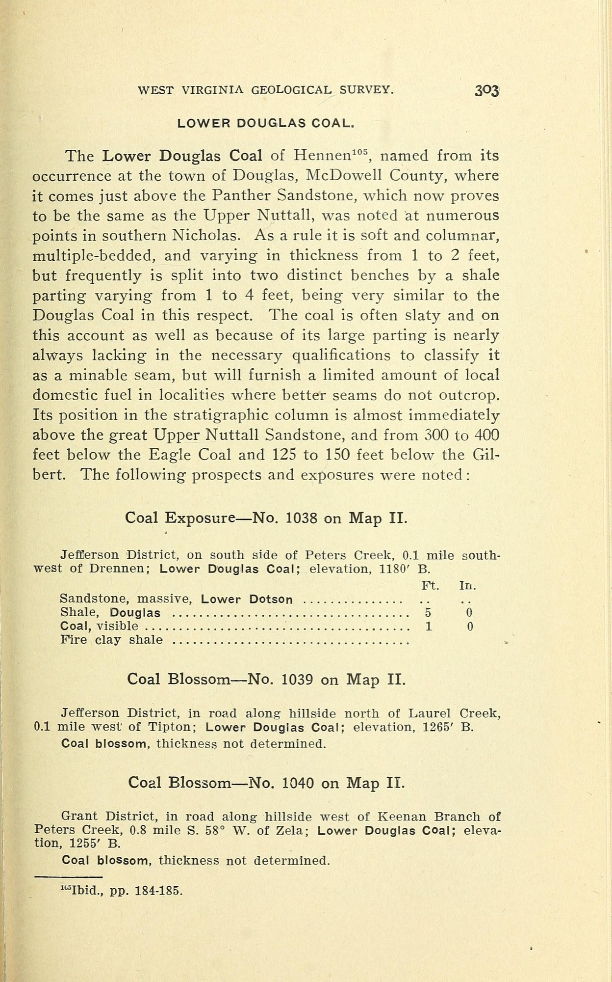
The coal record names the underground beds it covers: nearly 468 acres of coal in the Douglas, Gilbert, and Eagle seams.8 This is the coal that lies above creek level, and it came back to the family in 1992, when the Terry Eagle Coal Company signed its claim over to John S. Dalporto, returning the upper seams to the people who own the land above them.9 Two of the three named beds are the very ones the old mine maps show running through this property: the Gilbert seam, and the Eagle seam lying about 160 feet above it. The Douglas is the third of the upper seams.10 The deeper coal, below creek level, still belongs to other owners.
How it came down
The land reaches the Trust across three generations. The Dalportos were an Upper Kanawha Valley family, rooted at Glasgow, for whom this Nicholas County farm was a retreat rather than a home address.
Secondo Dalporto Sr. was born on September 14, 1917, and died on June 5, 2001. He founded Kanawha Valley Memorial Gardens at Glasgow and is buried there; his brother Primo lived from 1912 to 1990.11 Secondo's widow, Norma Lucille Nutter Dalporto, was a co-owner of the land rather than anyone who lived on it. She held two-thirds of the oil and gas beneath both tracts, and in 2004 she passed her share to her son John.12 She was living and of sound mind when she signed, on October 18, 2004. She died in 2013, and the family's cemetery listing at Glasgow records her beside her husband Secondo.
John Secondo Dalporto was born May 27, 1947, and died March 29, 2017; his estate was settled in Kanawha County.13 In 2018 his four children, Casey, Gabe, Hannah, and Nathan Dalporto, deeded their shares to Jeannean C. Dalporto,14 whose own half then joined with theirs to make the whole. Finally, in December 2021, Jeannean placed the gathered estate (surface, coal, and both oil-and-gas tracts) into the Jeannean C. Dalporto Inter Vivos Trust, confirmed by a correction filed the next year.15 Every one of the six tax records today traces back to a deed in that 2021–2022 stretch, so the Trust holds the whole estate, plainly and on the record.
A last word on where the lines fall. Only the two Grant District tracts, the roughly 469-acre farm and the small three-and-a-half-acre parcel on Keenan Branch, are the Dalporto farm. A few other small parcels in the family name turn up elsewhere in West Virginia, ordinary family lots with no tie to this land; they are not part of the estate on these pages, and none of them is the missing 97 acres.16 The farm is the farm: two surface tracts in Grant District, and beneath and around them the coal, oil, and gas the family has spent a generation gathering back into single hands.
Notes & sources
The Nicholas County Sheriff's tax office, real-property records for the 2025–2026 tax year, list six accounts in the Trust's name, with their descriptions and the values the county puts on them.↩︎
Surveyed exactly, the home tract measures 469.224 acres and the little Keenan Branch parcel 3.520 acres.↩︎
A search of West Virginia's statewide land-records map confirms the two Grant District tracts as the only Dalporto farm surface, records the just-under-17-acre Brown strip that adjoins the home tract, and finds no 97-acre Dalporto surface parcel anywhere in the state.↩︎
Today's surveyed 469.224 acres and the roughly 17-acre strip deeded to the Brown land together approach the older figure of about 486 acres by which the tract was long reckoned.↩︎
A search of West Virginia's statewide land-records map confirms the two Grant District tracts as the only Dalporto farm surface, records the just-under-17-acre Brown strip that adjoins the home tract, and finds no 97-acre Dalporto surface parcel anywhere in the state.↩︎
Norma L. Dalporto's 2004 deed to her son John S. Dalporto passed her two-thirds share of the oil and gas beneath both tracts, written in the deed's own shorthand as "486 A 97 A."↩︎
Both oil-and-gas rights were later placed into the Trust by separate deeds: the home-tract oil and gas and the detached 97-acre oil and gas each passed in its own deed.↩︎
The coal record covers 467.78 acres.↩︎
The Terry Eagle Coal Company's 1992 deed signed the above-creek-level coal (the Douglas, Gilbert, and Eagle seams) back to John S. Dalporto.↩︎
The West Virginia Geological and Economic Survey's records of the old Terry Eagle mines map the Gilbert and Eagle seams through the property, with the Eagle lying about 160 feet above the Gilbert.↩︎
A Find A Grave memorial records Secondo Dalporto Sr. (1917–2001), buried at Kanawha Valley Memorial Gardens in Glasgow, West Virginia; the same family listing records his widow, Norma Lucille Nutter Dalporto, who died in 2013, beside him.↩︎
Norma L. Dalporto's 2004 deed to her son John S. Dalporto passed her two-thirds share of the oil and gas beneath both tracts, written in the deed's own shorthand as "486 A 97 A."↩︎
The obituary of John Secondo Dalporto (1947–2017), from the Barlow Bonsall Funeral Home in Charleston, West Virginia.↩︎
In 2018 the four Dalporto children deeded their shares to Jeannean C. Dalporto; one of those deeds passed a half interest in the 467.78-acre coal, oil, gas, and minerals of Laurel Creek and Keenan Branch.↩︎
Jeannean C. Dalporto placed the estate into the Jeannean C. Dalporto Inter Vivos Trust in 2021, with the surface, coal, and oil-and-gas rights placed into it by deeds recorded in 2021–2022.↩︎
A search of West Virginia's statewide land-records map confirms the two Grant District tracts as the only Dalporto farm surface, records the just-under-17-acre Brown strip that adjoins the home tract, and finds no 97-acre Dalporto surface parcel anywhere in the state.↩︎
Coal & Mining
Under the eastern shoulder of the farm, two beds of coal lie stacked one above the other in the rock, and both were mined out long ago. Nearly all of that work happened east of here, under neighboring land; only the outermost edges of the tunnels reach back beneath this property, a little under ten acres in all, along its eastern and northeastern rim. What survives of the mining is mostly paper. The fullest record is a single certified map, drawn to close one of the two mines, that sets down in a careful surveyor's hand how far the tunnels ran and how they were built.
A map made to close a mine
The deeper of the two workings was the Cari-Eagle Mine #1, opened by the Terry Eagle Coal Company and running from the first of November, 1980. The paper that describes it is the mine's final map, the plan a company files once a mine is finished for good. It was drawn as it stood on June 1, 1984, and signed that July by a licensed engineer, Larry S. Harrah.1 It comes on two sheets. The first is the working sheet: the tunnels themselves, the notes on how the mine was run, and a small inset map that pins the site onto the government's topographic map of the area. The second is the certification sheet, carrying the title block, the key to the symbols, the readings on airflow, the survey markers, and the labels naming who owned the surface and who owned the coal beneath it.
The title block sets down the particulars an inspector would want: Grant District, Nicholas County, the scale of the drawing, and the direction of north. Sometime after the state took the map in, that summer of 1984, an archivist inked a few notes across its face in red, giving a filing number, the name of the seam, and the county: Gilbert, Nicholas.
That red note points to a small puzzle worth untangling. On the map, the coal is the Gilbert seam. The title carries the name, and the surveyors walked and marked the Gilbert coal that April of 1984 where it breaks into daylight along the hillside, a bed running roughly four feet thick. But the state's geological survey, which keeps the master map of every old underground working, files this very same mine under a different, standardized name: the Lower War Eagle.2 It is one mine under two labels: the local name the operator used, and the regional name the geologists use. Both point to the same set of tunnels.
How the coal came out
The map shows the workhorse method of Appalachian deep mining: the coal taken out in a grid of rooms, with square pillars of coal left standing between them, spaced roughly forty and fifty feet apart, center to center, to hold the roof up. A good share of the seam is left behind for good in those pillars, the price of keeping the roof up and the workings open while men and machines are underneath. The main tunnels are lettered A through I in the order they were cut. A conveyor belt ran down them to carry the coal out, with escape tunnels alongside, air crossings built to steer the fresh air where it was wanted, and walls of cinderblock and mortar sealing one current of air off from another. A five-foot fan, fifty horsepower, pushed fifty thousand cubic feet of air a minute through the mine; the returning air was checked once a week, and the map notes plainly, "No methane present." The rest of the gear was the ordinary kit of a small deep mine of its day: a pair of scoops, a drill, a machine to bolt the roof, and a cutting machine with a nine-foot bar.
Two things complicate the tidy grid. Around the edges, and where the new work met older tunnels, the map shows seals only proposed, not certified as actually built, along with stretches marked "area filled with rock" and one main tunnel stopped short where it struck solid rock. And an upper block is drawn in cross-hatched shading, under a blunt disclaimer that its full reach "cannot be mapped or certified... because of pillar removal," the little that is shown there having been supplied by the operator. That is the most dangerous kind of work: the pillars themselves pulled out on the way back, so the roof is let down to cave in behind the miners as they retreat, a zone whose true limits the engineer would not vouch for.
The map also plots a gas well driven straight down through the seam, a Stamnen and Associates well, ringed by a barrier of solid coal left in place to protect it, drawn as circles a hundred and two hundred feet out. There is a small irony in the paperwork: the standard block of notes on the same sheet declares "no oil or gas wells," which the plotted well plainly contradicts. It is a good reminder that a mine map is a working document, not a flawless one.
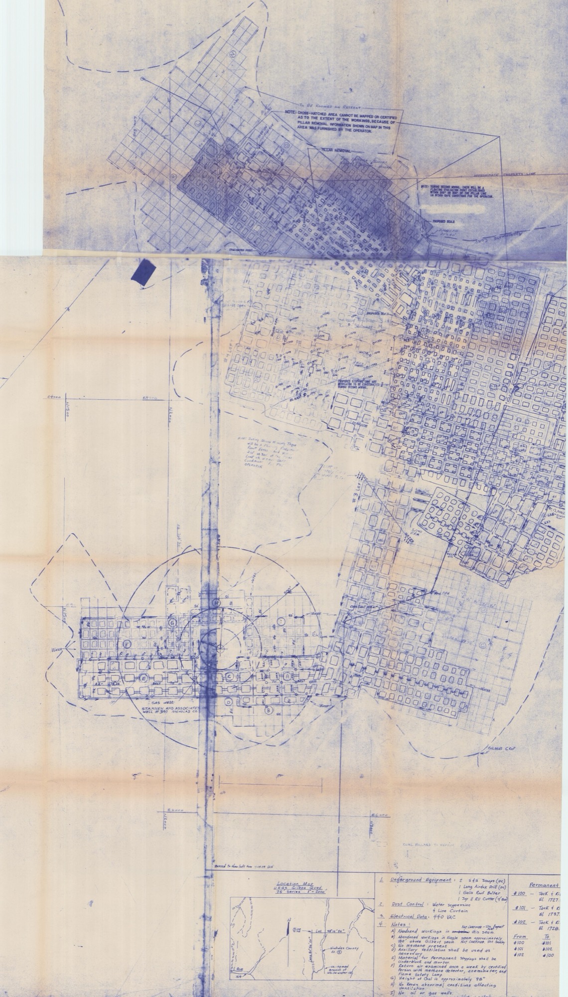
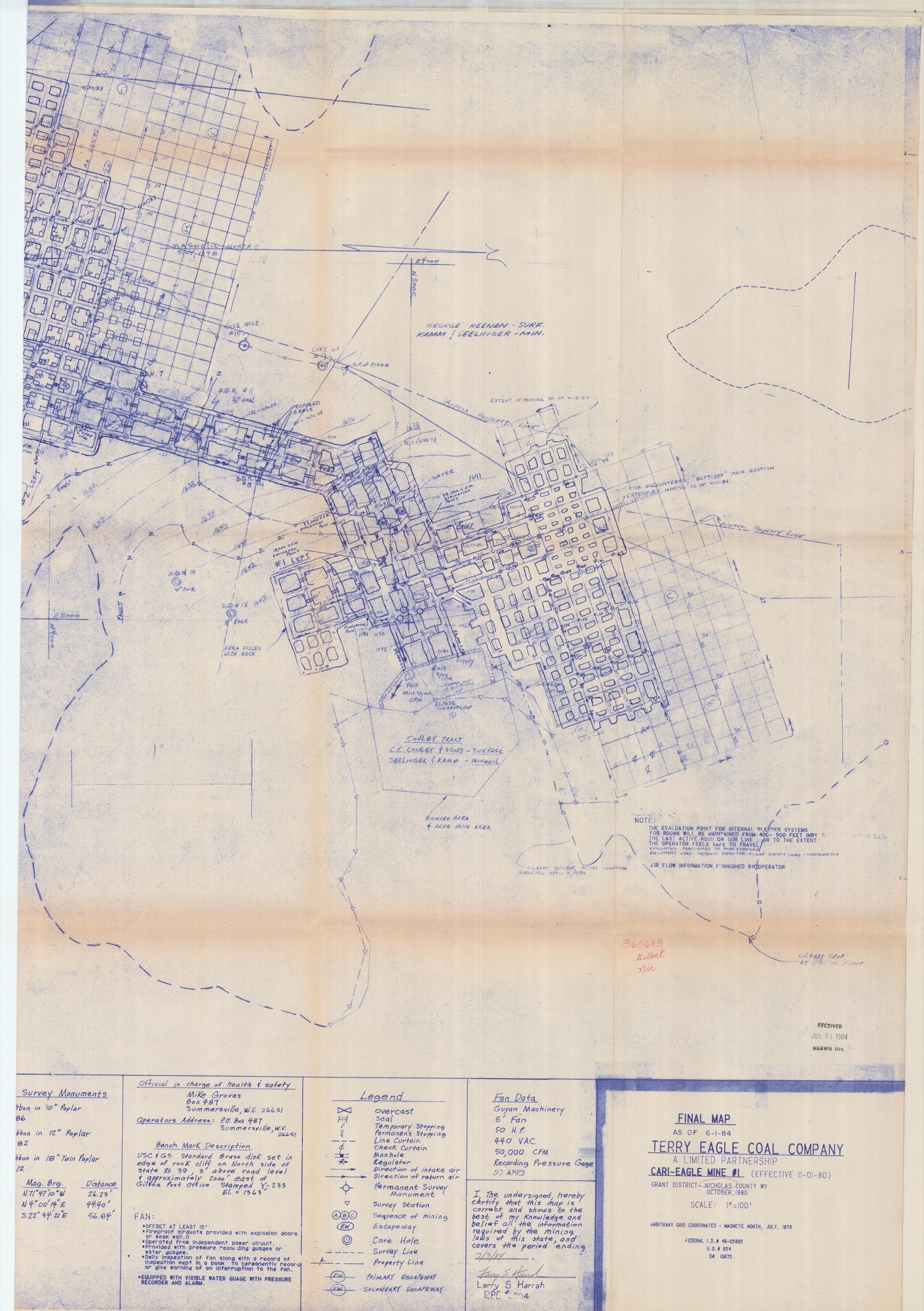
A single line on the map opens up the second half of the story. A note points to abandoned workings in the Eagle seam, roughly a hundred and sixty feet above the Gilbert: "NOT CERTIFIED. See Overlay." That upper void is a separate, older mine, the Greenbank Mine No. 1, kept under its own record in the state archive.3 So this corner of the ridge is doubly undermined: the Gilbert workings below, the older Eagle workings above, with about a hundred and sixty feet of solid rock between them.
What actually lies under the farm
Set against the surveyed property line, the two mines only clip the eastern and northeastern edge of the land. Most of both lie off it entirely, farther east. The deeper Gilbert workings nick the east-central edge, close to seven acres of it. The higher Eagle workings catch the northeast corner, about three acres more. Together that is on the order of ten acres of undermined ground, stacked in two seams, all of it in the east and northeast. Everything else runs on east, off this property, under land the map names for its owners, the Keenan and Conley tracts, with the coal itself held by Kamm & Seelinger. None of that is Dalporto ground; it belongs to the neighbors to the east. The mine's own surface buildings stood about eight hundred feet beyond the property's east edge, at the head of an unnamed branch of Whitewater Creek.4 Poe and County Route 129 lie off to the southwest.
The surveyors tied all of this to fixed points a later reader can still find. Their main reference was a brass survey marker set into a rock cliff on the north side of Route 39, about two thousand feet east of the Gilboa post office, its elevation recorded at 1,563 feet, together with three permanent markers near the workings, all a little above 1,700 feet.
Both beds come to daylight along the hillsides above the valley floors, which places the mining higher than the local streams, and that matters. In workings that sit above the level of the nearest creeks, water that seeps in drains back out by gravity where the coal meets the open air, rather than pooling. The tunnels do not fill and stand full the way they would in a mine dug below the streams, which floods once its pumps are shut off. The catch is at the surface: coal like this lies shallowest right where it breaks into daylight, so the rock between an old room and the ground above can be thin, and where the pillars were pulled, a roof fall can work its way slowly upward until the ground overhead sinks into a hollow.
These are long-abandoned workings, finished on paper more than forty years ago, and even that paper shows only proposed seals and a pillar-robbed block whose limits no one would certify. An old, unaired void is also a trap for what the miners called black damp: stale, oxygen-starved air, heavy with carbon dioxide and nitrogen, that pools in the dark and can smother a person without warning. It is a different killer from the explosive methane (firedamp, in the same old speech) that the working mine's fan was built to sweep away. Reason enough to treat any old opening, raw rock face, or sunken hollow on the eastern ridge as dangerous, and to stay well clear.
Notes & sources
The mine's certified final map, drawn by the company's surveyors as it stood on June 1, 1984, and signed that July by a licensed engineer, Larry S. Harrah. The operator, the Terry Eagle Coal Company, was a limited partnership. The map's two sheets are the fullest surviving record of the deeper mine: the grid of rooms and pillars, the gas well and its ring of protective coal, the airflow readings, and the survey markers all come off them. It is held today in the state geological survey's archive of underground mine maps.↩︎
The state geological survey keeps a single digital map of every old underground working across West Virginia. On it, this mine is filed under its standardized bed name, the Lower War Eagle, the same tunnels the operator's own map calls the Gilbert.↩︎
The older Eagle-seam void above the Gilbert, noted on the Cari-Eagle map as abandoned workings about a hundred and sixty feet higher, is a mine in its own right, the Greenbank Mine No. 1, with its own separate record in the state's mine-map archive.↩︎
The mine's surface operation, a few acres of buildings and yard, stood on that same spot east of the farm, roughly eight hundred feet beyond the property's east edge, at the head of the branch.↩︎
Water, Timber & Roads
Every acre of this farm sheds its rain toward two streams, Keenan Branch and Laurel Creek. Follow the paper trail of the place and much of it turns out to be a record of what people hoped to do with that water, the timber standing over it, and the roads that reach into it. Some of those plans were carried out lifetimes ago. One of the biggest was floated only within the last twenty years or so, and never happened at all. What follows is the story of the farm's water, its woods, and the right to cross its ground, told through the records they left behind.
The mine that was never built
Around 2010, a coal company called Keenan Minerals asked the state for permission to open a surface mine across this ground. The company had borrowed its name from the farm's own Keenan Branch, and its plan would have sent runoff into that stream and into Laurel Creek, the farm's own two, along with Whitewater Branch.1 Both of the farm's creeks drain to Peters Creek, and by way of Peters Creek to the Gauley River and on to the Kanawha, just as the West Virginia Geological Survey recorded in 1921 when it named the stream "Keenan Branch of Peters Creek." The coal the mine was after lay in a seam called the No. 2 Gas and in a group of beds known as the Eagle.
The state said no. It refused the mining application, and it turned down the companion permit the mine would have needed, the license any large earth-moving job must hold before it can let rain wash mud off bare ground and into a creek.2 Without that license, a mine this size could not lawfully have drained a drop into Keenan Branch or Laurel Creek, and federal records show no such operation ever existed, the fingerprint of a permit that was never granted. Because every part of the plan rode on that one application, none of it came to pass. The blasting plan and the survey of neighboring houses that would have come before the first charge, the ponds and channels meant to settle the runoff, and the wells drilled to take a baseline reading of the water were all pieces of a mine that was never dug.3 The plan even took stock of the household water close by: the wells and springs strung along Laurel Creek, Keenan Branch, Whitewater Branch, Meadow Creek, and Dalporto Fork.
Long before anyone drew up the mine, a road already climbed through here. The application folder holds a permission slip, one landowner letting the operation cross his property, and a state reviewer, reading the file in June 2011, noted the Dalporto family's own right to use a road that runs through land held by Christopher Brown and George Ragland.4 Ragland owned ground within a hundred feet of the proposed work and seems to have owned a stretch of the haul road itself; Brown was co-owner of the tract the road crosses. The family's right there is a right of passage and nothing more: permission to travel across the two men's land, carrying no ownership of the ground and none of the minerals beneath it.
The road is genuinely old. It comes down to meet County Route 129 near a cemetery, and the file calls it long-established, a road the Greenbank Coal Company once used to haul coal out of its underground mines back in the 1950s and 1960s.5 The right to cross traces back to a deed set down in the county courthouse.6 The thread worth pulling is this: the same corridor that once carried Greenbank's underground coal was the very one the later mine proposal was counting on to reach the coal it was after.
Keenan Minerals was not acting on its own. The ownership chart filed with its mine application set the company inside a single corporate family, the coal holdings of JSW Steel USA, reached through a ladder of parent companies.7 Keenan Minerals was the applicant; Prime Coal was the operating company just above it; and above that stood a run of holding companies (Purest Energy, then Periama Holdings, then Planck Holdings), with a single person, Perian Salviola, owning the whole of it at the top. The same chart named sister companies under the group: Meadow Creek Minerals, Hutchinson Minerals, RC Minerals, and Peace Leasing. Meadow Creek Minerals was only one of those siblings, its name a corporate label and nothing more; it does not place the farm in the Meadow Creek drainage.
What all of it comes to on the ground today is quiet. The only man-made works the state still keeps on its books nearby are the six abandoned shallow gas wells, which have a chapter to themselves. The proposed mine left behind a thick folder and not one shovelful of earthworks.
Pooling the minerals in 1978
Ownership of the minerals under the farm runs back to a sale in 1973, and Duke Coal Company, which by then held both the land and the minerals beneath it, signed an agreement in 1978 to pool them.8 That agreement survives only in the county's bound record books and has never been put online, so its exact reach can't be read here. But its timing tells a story. The six shallow gas wells on the farm were drilled under permits granted in 1975, 1978, and 1979, which drops the 1978 agreement right into the middle of that drilling.9 The likeliest reading is that it was a gas agreement, not a coal one.
To pool minerals is simply to gather several separately owned parcels, or several owners' shares of what lies beneath, into one shared arrangement, so that a single well, or a handful of them, can draw from the whole and the money is split among the owners by how much land each holds. It spares everyone a separate well on every property line, which is just what a run of gas wells crossing this tract's several owners would have called for. That reading, gas rather than coal, stays a reasonable guess, though, not a settled fact.
Keeping a record of the timber
When the farm's woods are cut, the work falls under a West Virginia law that ties logging to keeping the soil out of the streams.10 Under it, a logger must file a notice with the state's forestry office at least three days before the saws start, naming the logging company and the licensed logger running the job, the owners of the timber and the land, the county and nearest town, the watershed the work will drain into, how many acres will be cut and by what method, and the steps planned to hold back erosion. Nicholas County's notices are kept at the forestry division's regional office in Buckhannon.11 For a place whose water runs to Keenan Branch and Laurel Creek, that filing is the standing public record of any harvest.
Notes & sources
The mine application, filed with the state's mining and reclamation office as the Keenan Branch Surface Mine and later refused. The streams it would have drained and the coal it was after come from the application's own study of its likely effect on the local water; the Eagle beds it named were three: the Eagle, the Eagle A, and the Eagle Rider.↩︎
The stream-discharge permit filed with the mine application turns up among the state's denied applications in a 2013 permit-status report, and federal facility records return nothing under it, the mark of a permit never issued.↩︎
The blasting plan, the survey of neighboring houses, the settling ponds and channels, and the baseline water-test wells were all filed as part of the same refused application.↩︎
A permission letter and a state reviewer's note of 7 June 2011, both in the mine application; the crossing itself rests on a right-of-way recorded in the Nicholas County deed books.↩︎
The road's history, including its earlier use by the Greenbank Coal Company, is set down in the mine application file.↩︎
A permission letter and a state reviewer's note of 7 June 2011, both in the mine application; the crossing itself rests on a right-of-way recorded in the Nicholas County deed books.↩︎
The ownership chart filed with the Keenan Minerals mine application.↩︎
The Duke Coal Company pooling agreement of 1978, recorded only in the Nicholas County record books and never put online; the 1973 sale that roots the mineral title is recorded there as well.↩︎
State oil-and-gas well records; the six gas wells on the farm were permitted in 1975, 1978, and 1979.↩︎
The cutting notice is required by West Virginia's Logging Sediment Control Act; the form goes to the state Division of Forestry.↩︎
Nicholas County lies within the forestry division's region headquartered at Buckhannon.↩︎
Geology & Setting
The boundary lines only tell you where the farm ends. To understand why it looks and behaves the way it does, where a plow can go and where it can't, why the ridgetops stay in timber, what lies just past the eastern corner, and what public country spreads out beyond, you have to look at the ground itself: the rock underneath, the soils on top, the old mine workings nearby, and the parks along the river.
The ground below
Every acre of the farm sits on the same deep bed of stone, sandstone for the most part, with layers of shale and coal folded through it. It was all laid down around three hundred million years ago,1 back when this corner of the continent lay along the shore of a shallow inland sea. Sandstone makes up most of the thickness, but it is the coal, thin and dark between the harder rock, that has shaped so much of the land's later history. Every seam ever mined on or around the property comes out of this one bed, from the Stockton coal near the top down through the Eagle and the Gilbert far below.2
Those stacked coal beds are a record of how the ground was built, one flooding at a time. For ages the shoreline crept forward and drew back as the sea rose and fell and the rivers pushed their mud outward. Each time the water came in, it drowned a coastal swamp and buried its peat under a fresh load of sand and mud. Squeezed and heated over the millions of years since, each drowned swamp hardened into a seam of coal, and the sand and mud between them turned to the sandstone and shale that hold one seam apart from the next. Read from top to bottom, the coal beds are simply those floodings counted off in order.
On top of that rock lie the soils, and they sort themselves by slope as neatly as anything on the farm. The flat valley bottoms hold the best ground, deep, well-watered dirt that the government's soil survey gives its highest rating, prime farmland: the kind of soil best suited to steady cropping, with the least work and the least washing away.3 The middle slopes fall a step below, still genuinely productive, but not bottomland. And the steep, stony ridges at the crown of the property are rated poorest of all, which is exactly why they stay in timber and pasture instead of under the plow. On this land the ratings follow the lay of the ground so closely that they all but trace the contour lines.
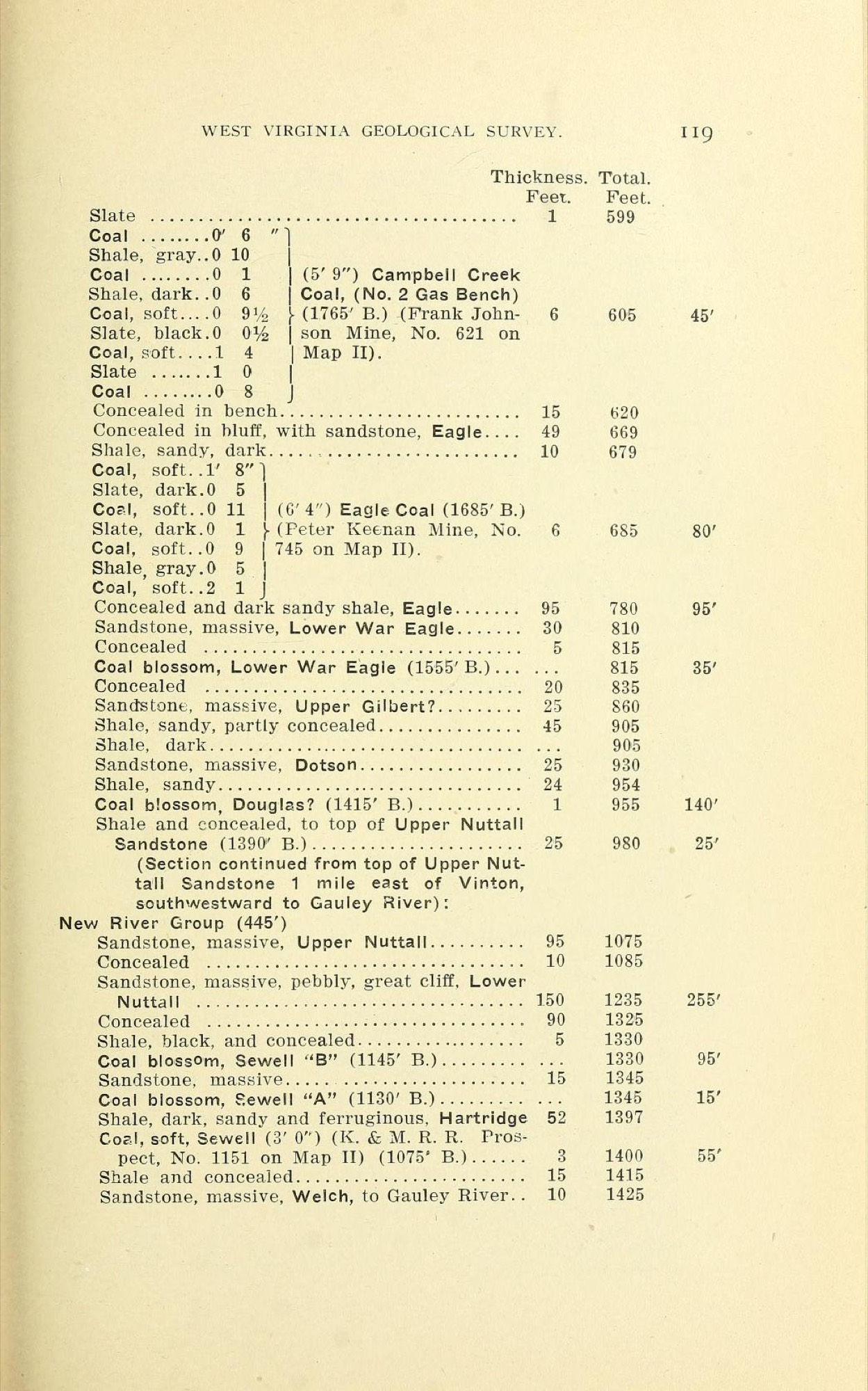
Beyond the boundary
No mine entrance opens onto the farm itself. The nearest are the old Cari-Eagle surface works, about eight hundred feet east of the line, at the head of Whitewater Branch: off the property, sealed, and signed off by state regulators as reclaimed back in 1993. A little farther down that same drainage, something like half a mile to the east-southeast, the state still keeps an eye on the Whitewater Branch area, where water seeps from long-abandoned underground tunnels.4 What lies below ground along the farm's eastern edge, the seams, their depths, and the workings that just clip the property, is a longer story, told in full on the Coal & Mining page.
None of the farm is public or protected; it is private ground, all of it. But it sits within easy reach of the belt of parks and conservation land that has grown up along the Gauley River and Summersville Lake. Four public places frame the farm's corner of the county.5 There is the Gauley River National Recreation Area, run by the National Park Service; Summersville Lake, held by the U.S. Army Corps of Engineers for recreation and flood control; the wildlife management area along the lake's shores, looked after jointly by the Corps and West Virginia's wildlife agency; and Carnifex Ferry Battlefield, a state park on a Civil War field. Every one of them lies beyond the boundary. None of them touches the farm.
Notes & sources
The particular layer of rock is the one the West Virginia Geological & Economic Survey mapped, on its 1968 state geologic map, as the Kanawha Formation.↩︎
More than a dozen named coal beds are stacked through this rock: Stockton, Coalburg, Winifrede, Chilton, Williamson, Cedar Grove, Alma, Peerless, Campbell Creek, Powellton, Eagle, Gilbert, and Douglas, roughly one for each ancient swamp that was drowned and buried in its turn.↩︎
The ratings come from the U.S. Department of Agriculture's soil survey for Nicholas County. It maps about a dozen different soils across the farm: the two bottomland soils, called Pope-Craigsville and Buchanan, rate as prime farmland; most of the rest, on the middle slopes, count as farmland of statewide importance; and the steep, rocky ridge soils, Dekalb, Kaymine, and Highsplint, are not prime farmland at all.↩︎
The Cari-Eagle mine's surface operations were reclaimed, the ground replanted and, in 1993, signed off by state regulators. The state still lists the old Whitewater Branch workings in its inventory of abandoned mines, where water continues to drain from them.↩︎
The four public units are drawn from the national database of protected lands kept by the U.S. Geological Survey.↩︎