Reading the Cari-Eagle Mine Map (WVGES doc 365683)
Depth, seals & access
Two vertically stacked voids clip the parcel's east / northeast corner — about 10 acres in all — in two coal seams roughly 160 ft apart. Both mines run mostly off-parcel to the east, on the neighbouring Keenan / Conley mineral tracts. The deeper Cari-Eagle Mine #1 worked the Gilbert seam (the WVGES standardized bed Lower War Eagle); about 160 ft above it, the older Greenbank Mine No. 1 worked the Eagle seam.
Seam, thickness & depth of cover
| Working | Seam | Thickness | On-parcel void | Depth of cover | Status |
|---|---|---|---|---|---|
| Cari-Eagle #1 — Terry Eagle Coal, final map 1984 | Gilbert / Lower War Eagle | ~4.0 ft (48 in) | 6.76 ac | ~100–250 ft typical (0 at outcrop, ~360 ft under the ridge) | Above-drainage; portals reclaimed & sealed by 1993 |
| Greenbank No. 1 — Greenbank Coal, 1961 | Eagle | 0.7–4.8 ft (avg ~2.5 ft) | 3.19 ac | ~160 ft under the ridge (0 at outcrop) | Pre-law; no engineered seals; likely collapsed |
Depths of cover are estimated from the bare-earth LiDAR surface minus the mapped seam elevations. The Eagle seam elevation (~1,800 ft) is documented from a 2009 core (KB-2-09); the Gilbert lies ~160 ft below it. Both workings are above-drainage.
Mining method & seals
- Cari-Eagle #1 is room-and-pillar (pillars on ~40–50 ft centres) with belt haulage, primary and secondary escapeways, overcasts and stoppings — plus a retreat / pillar-removal block whose extent the mine's own final map "cannot map or certify," an elevated roof-fall and subsidence risk. That map shows only proposed seals at the old-works junctions, with sections "filled with rock" or stopped at rock. A gas well (Stamnen & Associates #390) passes through the seam inside a 100/200-ft barrier pillar.
- Greenbank No. 1 is a 1961, pre-SMCRA deep mine driven from the Eagle outcrop, plus 1950s–60s augering. It carries no SMCRA permit and no documented engineered seals; its outcrop portals are most likely caved with age. The Cari-Eagle overlay labels these Eagle workings "NOT CERTIFIED."
Access & portals — all off-parcel
- No mine entrance or portal lies on the parcel. The Cari-Eagle surface facilities and portals sat about 800 ft east of the parcel's east edge (SMCRA permit U065400), and were reclaimed and released — Phase-2 revegetation approved 1993 — i.e. sealed and covered.
- The abandoned Gilbert workings discharge mine water at their down-dip portals into Whitewater Branch, a WVDEP AML mine-drainage problem area (WV002592) about 0.7–0.9 km east / south-east of the parcel. A separate AML waterline project (WV006653) replaced mine-affected water supplies nearby.
- Old haulage reached the workings from County Route 129 (the parcel's "off Rt 129" access), used by Greenbank Coal for deep-mine haulage.
The safety reality
These are abandoned pre- and early-law room-and-pillar and auger workings. Cari-Eagle's mapped portals were reclaimed and sealed by 1993, but the mine's own map shows only proposed seals and an uncertifiable pillar-removal zone, so roof-fall and surface subsidence are real; the 1961 Greenbank mine has no engineered seals and is most likely collapsed. Any open void holds oxygen-deficient, toxic “black-damp” air and pooled, acidic mine water over an unstable, caving roof. Entering these workings is illegal and can be immediately fatal — treat every old portal, subsidence hole, or highwall opening as deadly and stay out.
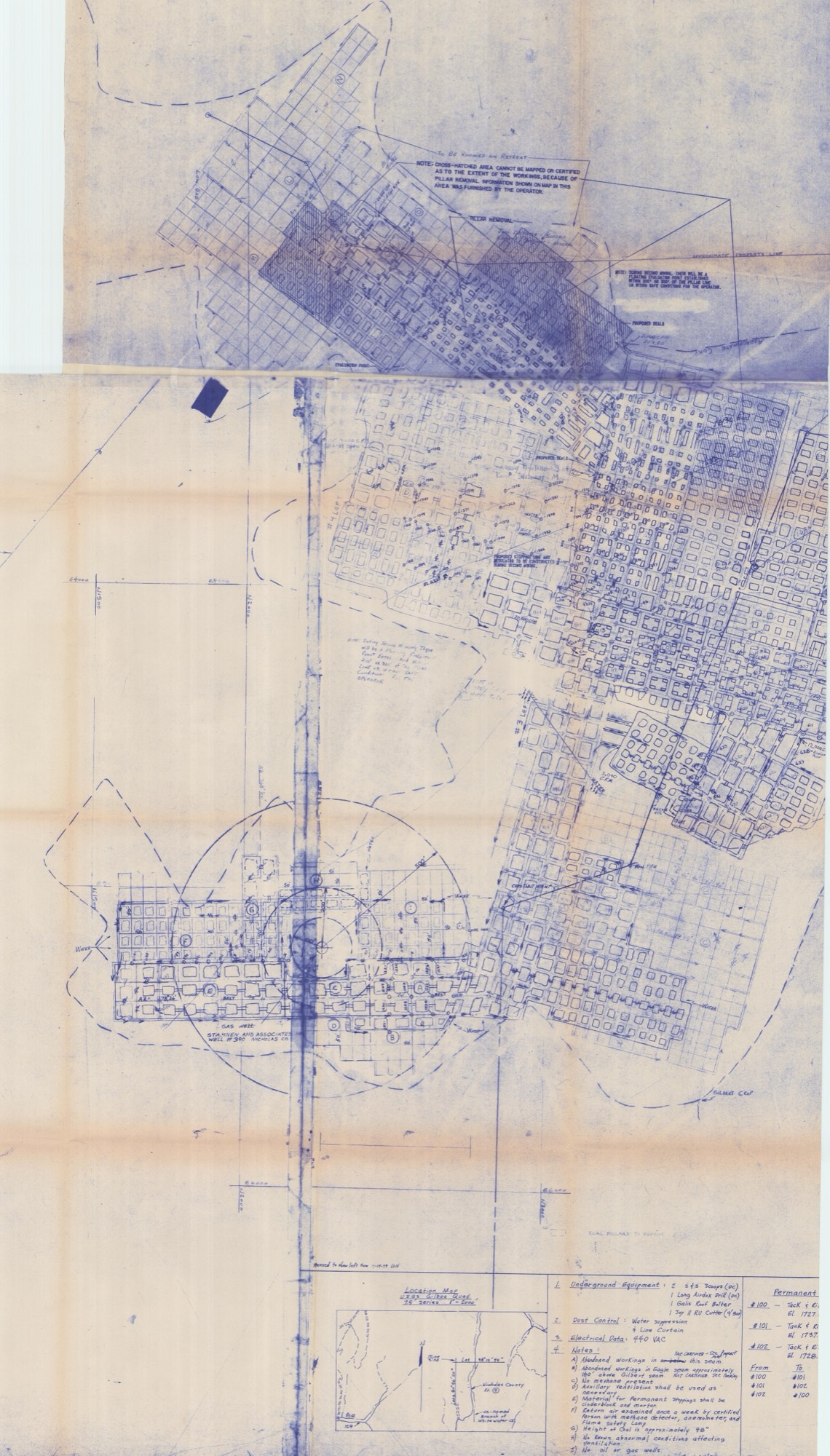
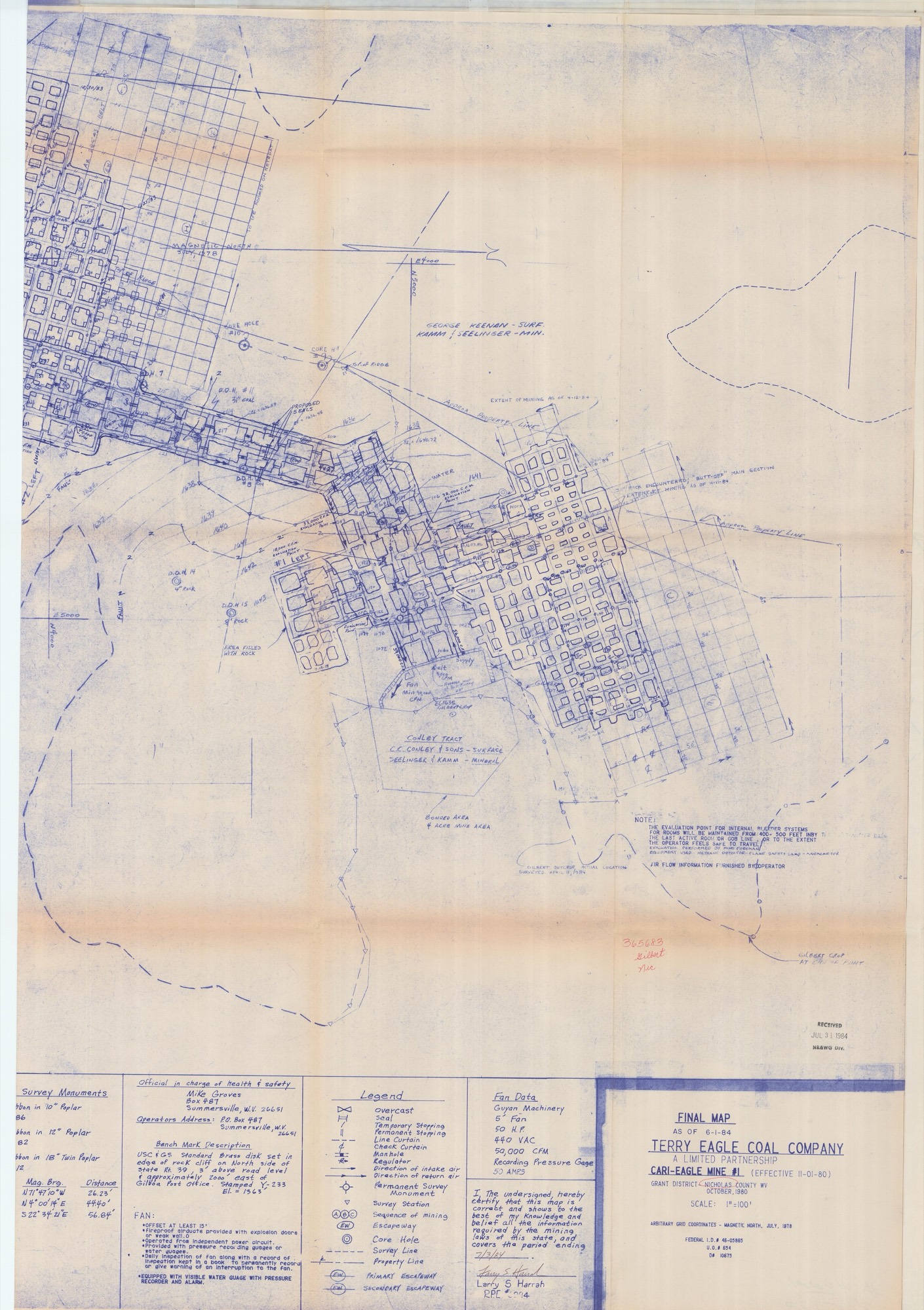
The two scanned sheets of the mine's certified final map:
cari_eagle_365683_01.jpg(5546 x 9726 px, 12.2 MB) — working sheet: main room-and-pillar workings, gas-well barrier, notes block, USGS-quad location inset.cari_eagle_365683_02.jpg(5161 x 7321 px, 7.4 MB) — certification sheet: title block, legend, fan data, survey monuments, tract-ownership labels, "extent of mining" limit lines.
Title block (sheet 02)
- FINAL MAP AS OF 6-1-84
- TERRY EAGLE COAL COMPANY — A LIMITED PARTNERSHIP
- CARI-EAGLE MINE #1 (EFFECTIVE 11-01-80)
- GRANT DISTRICT, NICHOLAS COUNTY WV — OCTOBER 1980
- SCALE 1"=100'; ARBITRARY GRID COORDINATES, MAGNETIC NORTH, JULY 1978
- FEDERAL I.D. # 46-05885 ; U.O.# 654 ; D# 10675
- Certified 7/3/84 by Larry S. Harrah, R.P.E.; RECEIVED JUL 31 1984, N&WG Div.
- Red archivist annotation on map face: "365683 / Gilbert / Nic"
Seam (IMPORTANT correction)
The map is a GILBERT-seam mine (title-page red note "Gilbert", "GILBERT CROP / GILBERT OUTCROP ACTUAL LOCATION SURVEYED APRIL 11 1984", coal height ~48"). The WVGES digital WV_underground_mining layer codes doc 365683 as Lower_War_Eagle (LWE) — its standardized bed name for the same workings. So: map local name = Gilbert; WVGES bed code = Lower War Eagle. Same void, two names — the map itself says Gilbert, while the WVGES database files it under Lower War Eagle.
Workings, portals, controls (sheet 01 + 02)
- Classic room-and-pillar panel: pillars on ~40' and ~50' centers, entries lettered by sequence of mining A–I, belt line ("BELT") down the mains, escapeways (primary/secondary), overcasts, permanent/temporary stoppings (cinderblock & mortar), regulators.
- Ventilation: Guyan Machinery 5' fan, 50 HP, 440 VAC, 50,000 CFM; return air checked weekly; "No methane present."
- Underground equipment: 2 S&S scoops, 1 Long Airdox drill, 1 Galis roof bolter, 1 Joy 11RU cutter (9' bar).
- Seals: several "PROPOSED SEALS" drawn at the perimeter/old-works junctions; "AREA FILLED WITH ROCK"; "ROCK ENCOUNTERED 'BUTT-OFF' MAIN SECTION."
- Pillar removal / retreat: an upper cross-hatched block labeled "CROSS-HATCHED AREA CANNOT BE MAPPED OR CERTIFIED AS TO THE EXTENT OF THE WORKINGS, BECAUSE OF PILLAR REMOVAL. INFORMATION SHOWN ... FURNISHED BY THE OPERATOR" — i.e. second-mining/retreat with uncertain limits.
- Gas well through the seam: "GAS WELL — STAMNEN AND ASSOCIATES WELL #390 NICHOLAS CO." with a left protective barrier pillar (concentric 100'/200' radius circles). Note "I) No oil or gas wells" on the standard notes list is contradicted by this mapped well.
- Two-seam stack (key for the parcel): Note B — "Abandoned workings in Eagle seam approximately 160' above Gilbert seam. NOT CERTIFIED. See Overlay." The Eagle-seam void ~160 ft above this Gilbert mine is the Greenbank Mine No.1 (doc 903219, below). Note A — "Abandoned workings in this seam ... NOT CERTIFIED — see property map."
- Bench mark: USC&GS brass disk Y-233, El. 1563, in rock cliff N side of WV Rt 39, ~2000' E of Gilboa P.O. Permanent monuments #100/#101/#102 (tack & ribbon) El. ~1727–1737.
Tract-ownership labels on the map (these are the mined tracts — NOT Dalporto)
- "GEORGE KEENAN – SURF. / KAMM & SEELINGER – MIN." (north)
- "CONLEY TRACT / C.C. CONLEY & SONS – SURFACE / SEELINGER & KAMM – MINERAL" (center)
- "BONDED AREA / 4 ACRE MINE AREA" (the small bonded surface footprint)
- Multiple "APPROXIMATE PROPERTY LINE" and "EXTENT OF MINING AS OF 4-11/4-12-84" limit lines.
Georeference (location inset, USGS Gilboa 7.5', 1"=2000')
- Mine-site datum crosshair: Lat 38°15'45" (38.2625), Long 80°56'20" (-80.9389).
- Landmarks: POE and Route 129 to the SW; Nicholas County Rt. 9 (N–S) and "Un-named Branch of Whitewater Ck." to the E.
- This datum sits ~800 ft EAST of the Dalporto parcel's east edge (parcel E ≈ -80.9416). It coincides exactly with SMCRA permit U065400 (Terry Eagle underground surface facilities, 7 ac) — i.e. the portal/facilities area is just off-parcel to the east.
Void extent toward / under the Dalporto parcel (from WVGES clip)
- Cari-Eagle #1 (Gilbert): the room-and-pillar void reaches WEST from the datum and its WVGES polygon clips ~6.76 ac inside the parcel (east-central; clipped bbox lon -80.9471…-80.9373, lat 38.2531…38.2647).
- Greenbank Mine No.1 (Eagle, ~160' above): clips ~3.19 ac inside the parcel (NE corner; bbox lon -80.9433…-80.9408, lat 38.2608…38.2632).
- Combined ~10 ac of the parcel is undermined, in two vertically-stacked seams, in the east/NE. Most of both mines lies off-parcel to the east on the Keenan/Conley (Kamm & Seelinger mineral) tracts.